Leg Departure Planner — what will the water be doing where you'll actually be?
Renamed 24 August 2026 — this tool was called the Next Leg Planner when this went out. It is now the Leg Departure Planner: same tool, same link. A new tool on the Tools page. It takes your trip's next leg, splits it into stretches, and shows the wind and the sea for each one at the time you would really be there — then lets you slide your departure and watch the whole day change.
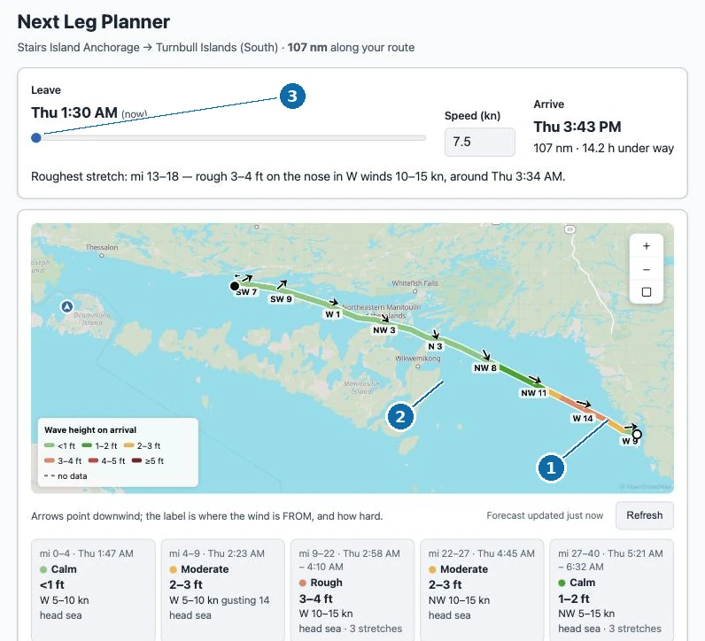
Where to find it
Open Tools, then Leg Departure Planner. Or go straight to /tools/next-leg-planner. There is nothing to fill in — it already knows where you are and where you said you were headed next.
One leg, stretch by stretch
A forecast for "the lake" is not much use on a hundred-mile day. This reads the route your trip actually plans to run, cuts it into stretches, and works out when your boat would reach each one at your cruising speed.
Then it reads that stretch's own wind at that hour, measures the run of open water the wind has crossed to get there (its fetch), and computes the sea from the two. The line on the map changes colour along its length — calm where it is calm, coloured up where it is not — and each stretch carries an arrow saying where the wind is from and how hard.
Above the map, one sentence names the worst of it: which miles, how rough, from which direction, and roughly when.
Slide your departure
The whole point of asking when to leave is being able to try other answers. Drag the departure slider and everything re-reads — the colours on the map, the wind on every card, the arrival time, and the rough patch sliding to a different part of the day. It happens as you drag, because everything it needs is already in front of you.
It also says when an arrival lands outside daylight, using the real sunrise and sunset for that place and date.
Currents, and where we have them
On the Gulf ICW and the rivers, each stretch also says what the current will be doing — 1.8 kn with you, 1.4 kn against you — read at the hour you would be passing it, so it moves with the departure slider like everything else. Tidal current comes from NOAA's own prediction stations for the reaches you will run; river current comes from a live gauge reading, turned onto your course.
Where we do not have it, it says which kind of silence that is. Lake water gets "no tidal current here." Lock-regulated water says so. And the Atlantic ICW says plainly that we have not mapped current stations to it yet — because an inlet current on the east coast is exactly the thing you would want to know, and we would rather tell you we do not have it than quietly show you nothing.
Where every number came from
Under the leg is a panel naming the source of each number: the wind forecast and when it was fetched, how the wave height is computed and from what, which of our own depth-and-shoreline grids measured the fetch and how many stretches sat inside that coverage, and where the clock times and sunset come from.
Where a stretch falls outside that coverage, it shows the wind and declines the wave height rather than guessing — and says so, because a gap in what we have is not the same as calm water.
What it is — and isn't
This is a planning aid, not navigation. Wave heights are for locally generated, wind-driven sea: after a big wind shift, expect leftover chop this does not model. It uses a deep-water model, so shallow water and wind-against-current effects are not in the picture, and currents are reported beside the sea state rather than folded into it.
The leg is capped at 24 hours of running. Rivers and canals show wind but no wave height, because a river is too narrow for a wind sea to build.
Always check the official marine forecast before you leave the dock.