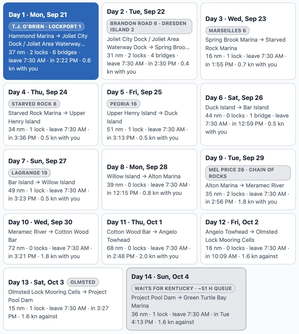
A run longer than a day is now a list of days — each cut at a real overnight stop, every lock and bridge checked on the day you actually reach it. Hammond to Green Turtle Bay is 14 days at 8 hours a day, and the planner says so, day by day.
One chip per day, Hammond to Green Turtle Bay: the night it ends at, the locks it passes, when it leaves and when it gets in.
Days, not one long night
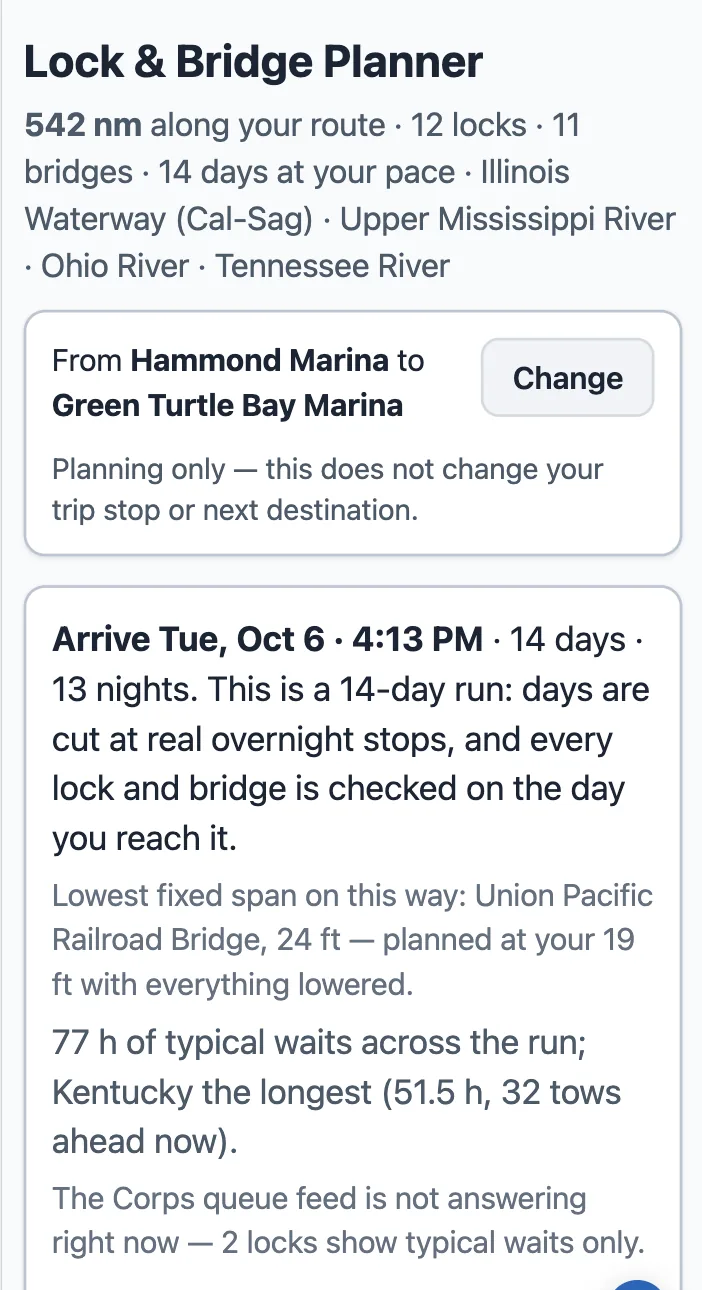
The run's verdict at the top of the page: when you get in, how many days, and the longest wait on the way.
Tools → Lock & Bridge Planner. When your run does not fit in a day, a row of day chips appears under the controls: "Day 1 · Mon, Sep 21 — Hammond Marina → Joliet City Dock · 37 nm · 2 locks · 6 bridges · leave 7:30 AM · in 2:22 PM". Tap a day and the page below is that day: its map, its staircase, its locks and bridges in order, its cards. On a phone the chips stack and the day you tap opens under its chip.
Every gate on its own day
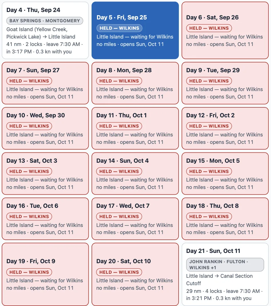
A different run, Green Turtle Bay to Demopolis: the red chips are the days the boat waits at Little Island for Wilkins Lock to reopen.
Wilkins Lock on the Tenn-Tom is closed through October 10. Leave Green Turtle Bay for Demopolis on September 21 at 8 hours a day and you reach it Friday September 25 — so the plan holds the boat at Little Island, one red chip per day, until the lock opens on October 11, and the days after it carry on from there. No day is planned through a gate that is shut on that day.
Two ways on
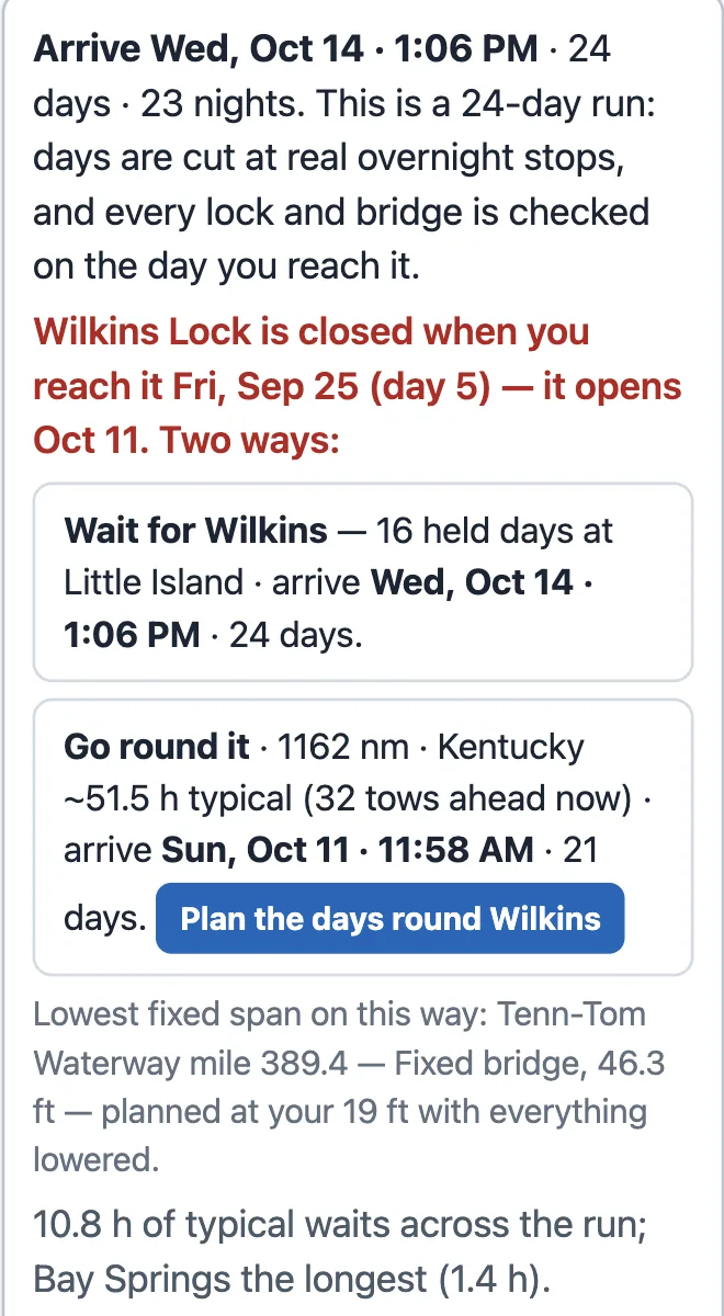
The verdict names the lock that stops you, the day you reach it, and prices both ways on.
The verdict at the top says it plainly: "Wilkins Lock is closed when you reach it Fri, Sep 25 (day 5) — it opens Oct 11. Two ways." Wait for it — sixteen held days, arriving Wednesday October 14 at 1:06 PM — or go round it by the Tennessee, the Ohio and the Mississippi: 1,162 nm, arriving Sunday October 11. One tap plans the days the other way.
You own the mornings and the nights
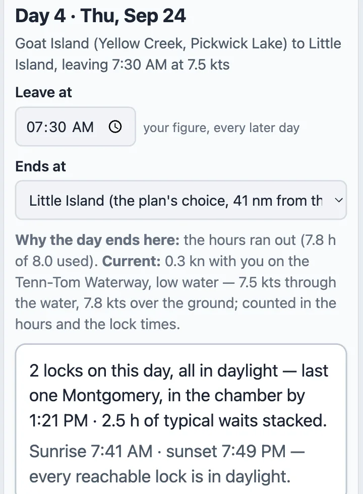
A day's card: Leave at, Ends at, why the day ends where it does, and what the day's locks do.
"Hours a day" (your boat profile's figure) decides the cut; a day never plans past sunset unless you leave late on purpose. Each day's card has "Leave at" and "Ends at" — pick a different marina or anchorage from the ones near the cut, and the days after it re-plan; the days before it stand. Nothing is written to your trip: the plan lives in the link.
Where to find it
Tools → Lock & Bridge Planner. Pick any two places with Change, or let it take your trip's next leg. It needs an active trip: the plan runs on your boat's speed, air draft and hours a day.
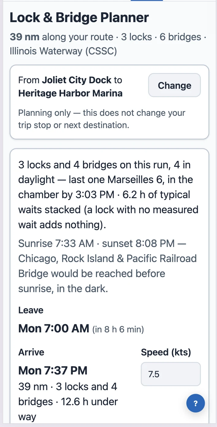
Pick where you start and where you stop, and the Lock & Bridge Planner lays out every lock and bridge between them in order — when you reach each one, whether it will be open, how long you wait, and where sunset falls. It runs on your boat, your speed and your departure time, and it works on the phone. Bridge Clearance Check now knows the draws too: which ones must open for your air draft, and what it takes to get them opened.
Tools → Lock & Bridge Planner. Joliet City Dock to Heritage Harbor Marina, leaving Monday at 7:00 AM.
The Lock & Bridge Planner
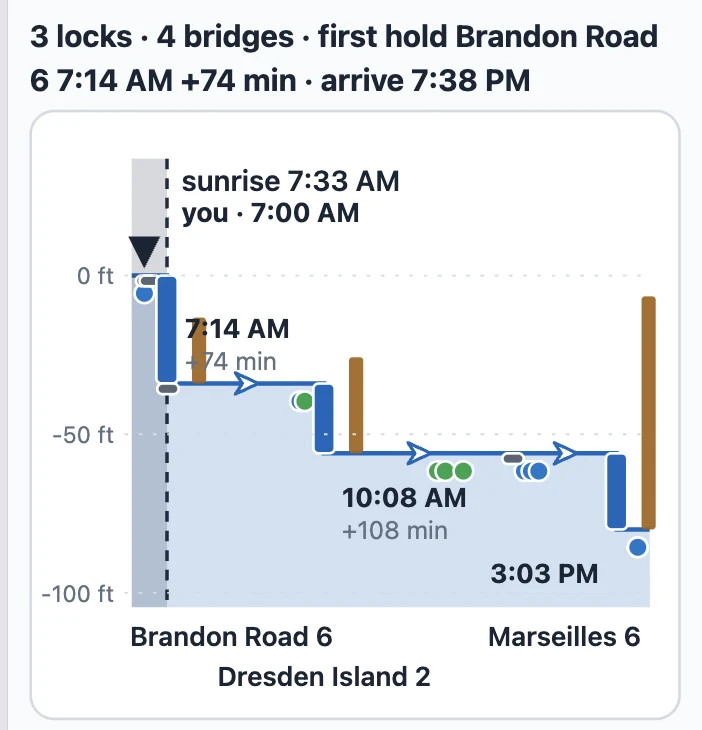
Each lock is a step; the bar on it is the wait. The summary line above says the first hold and the arrival.
Tools → Lock & Bridge Planner. The run is your trip's next leg by default; tap Change to plan any two places. The map shows the run, the chart shows the locks as steps with the waits drawn on them, and the list under it names every gate with its time and its source. A gate that would hold you says so — Brandon Road 6 · 7:14 AM · +74 min — and the arrival at the top already includes it. A bridge that opens when you get there says nothing, which is the point. On a phone the three pictures sit one under the other: map, chart, list.
On a bigger screen
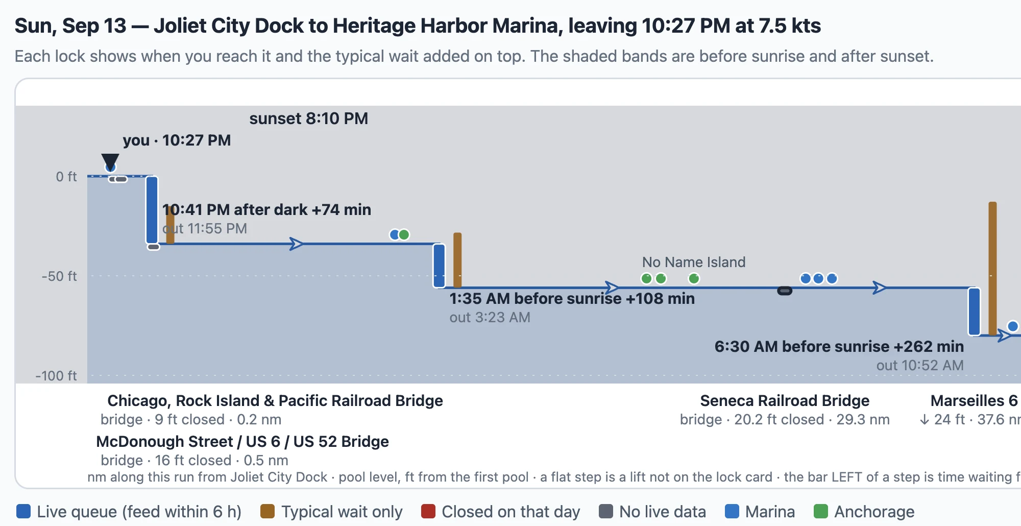
The same run on a desktop, leaving at night: every step says after dark or before sunrise, and the shading says why.
A tablet or a desktop draws the chart wide, with each gate's out time under its arrival and the bridges named under the axis with their closed clearance and mile.
The map and the list
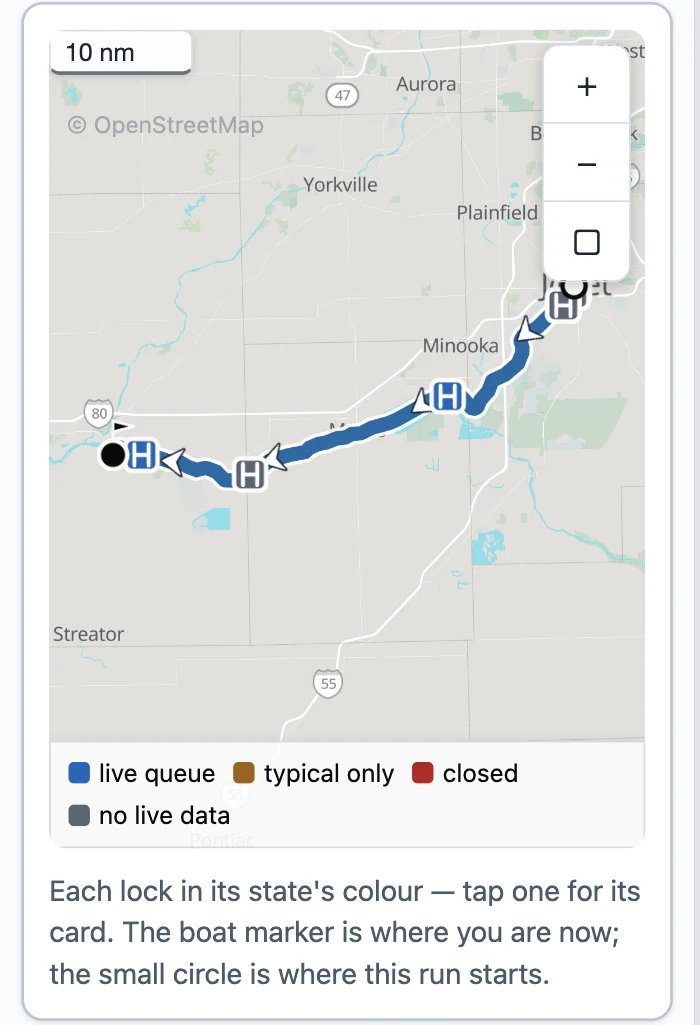
Every lock on the map in its state's colour — live queue, typical wait only, closed, no live data — and a tap opens its card. The list is the working surface on a phone: the row says the time, the wait and where the wait comes from; the card under it carries the chamber, the VHF channel, the day's hours and what the operating authority publishes.
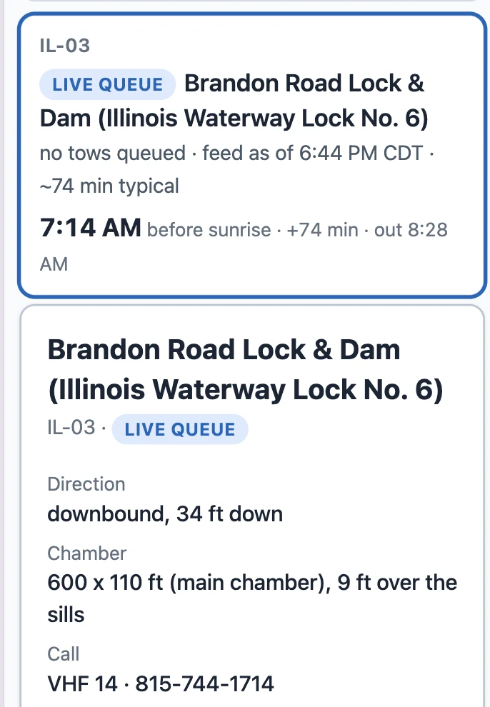
A lock's row, and its card
Brandon Road: no tows queued on the Corps feed, 74 minutes typical, in the chamber at 7:14 and out at 8:28. The card says the lift, the chamber, the channel to call and the hours the district publishes for that day.
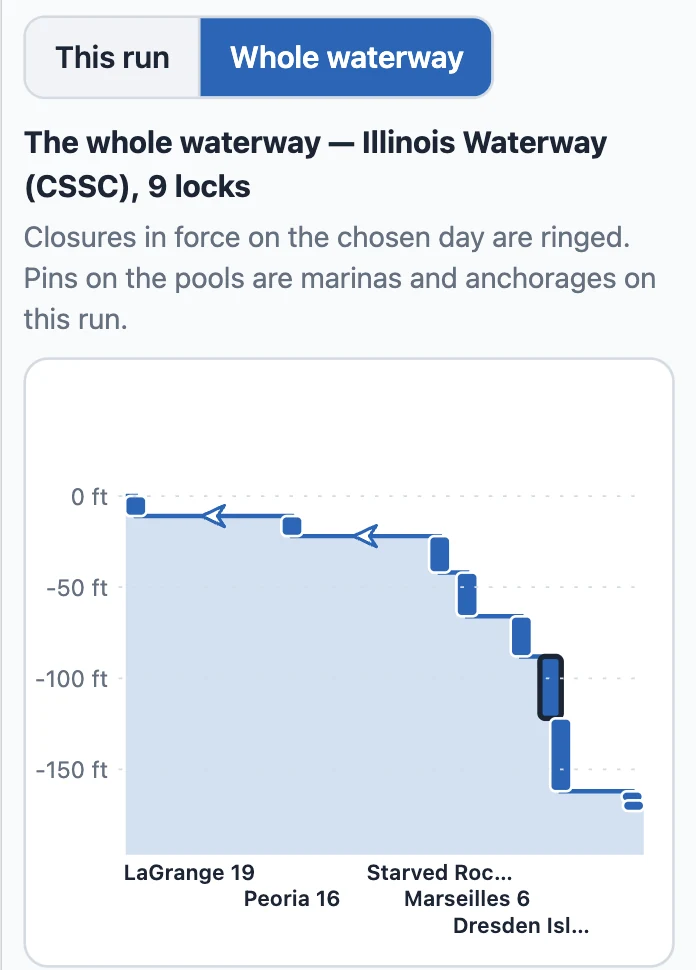
The whole waterway
Whole waterway shows the ladder past your run — every lock on the river, a closure in force on the chosen day ringed — so you can see what is coming the day after.
Where the hours come from
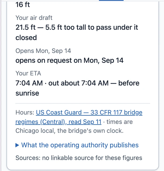
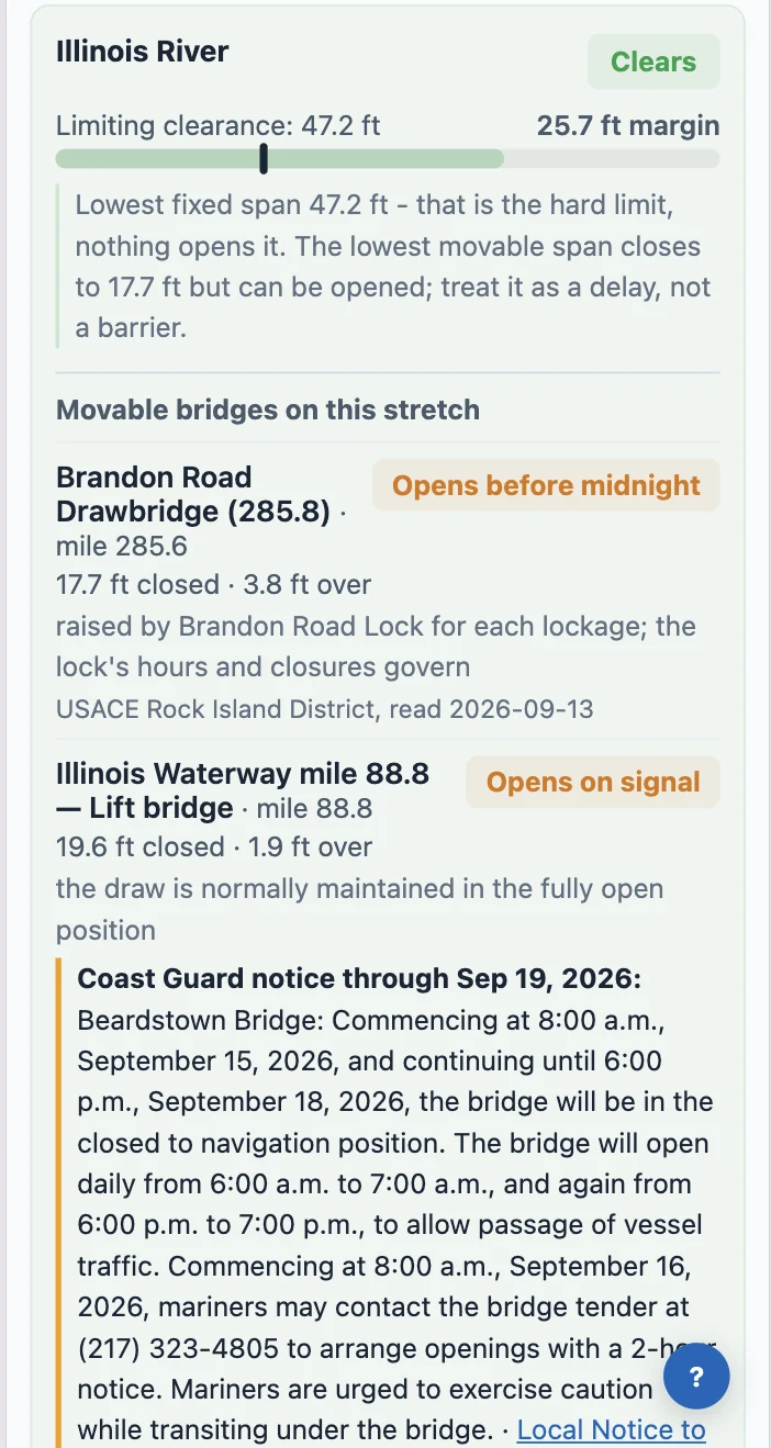
We read the published hours from the people who run the gates: the Coast Guard's bridge regulations (33 CFR 117), the New York State Canal Corporation, Parks Canada, the St. Lawrence Seaway and eleven Corps of Engineers districts — 312 schedules in force, re-read every night, each shown with its source and the date we read it. 207 of the 279 movable bridges on the Loop answer. The Coast Guard's Local Notice to Mariners rides on top: a bridge under repair or a lock on a short week shows as a notice on its card, and where the notice states its hours plainly the planner holds you to them.
Bridge Clearance Check: the draws that must open for you
Tools → Bridge Clearance Check. Under each stretch of your route it now lists the draws your air draft can't clear closed and what it takes to get them opened — on signal, on the hour, on four hours' notice — with the regulation's own words and the date we read it. A span too low for your boat that never opens is said as a span you cannot pass, not as a bridge to hail. The Lock & Bridge Planner reads the same rows, so a draw that holds you there is the same draw, with the same time, here.
The day card says who holds you
My Trip's day card and the morning briefing walk today's leg gate by gate at your own usual departure hour and say only what binds: "Northeast 14th Street Bridge, Pompano Beach opens at 9:15 AM; you reach it 9:05 AM — 10 min to wait." A bridge that opens only on notice tells you the deadline to call. Leg Departure Planner shows the shut hours as a band on the departure track and prices the hold into your arrival; Plan Around Your Dates counts a lock that eats the day as the day it eats.
Seasons, from the source
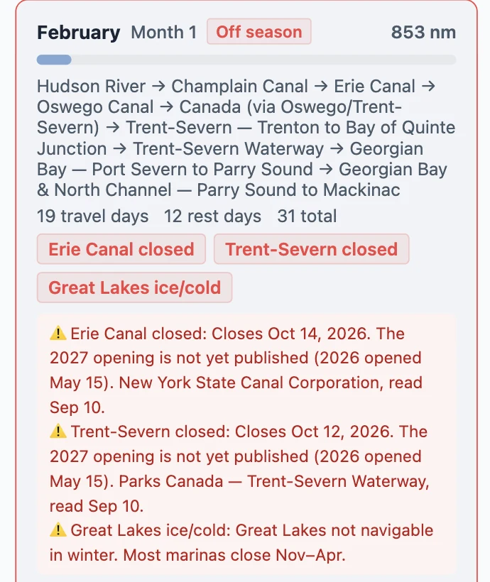
Seasonal Timing Planner used to carry a sentence we typed two years ago. It now reads the canal's own published season, and when a season ends and the next isn't published, it says so. When an authority changes a gate's hours and your plan had you there, the Dates card, the day card and the briefing say it in one line — only when the answer changed, not when the paperwork did.
What it cannot do yet
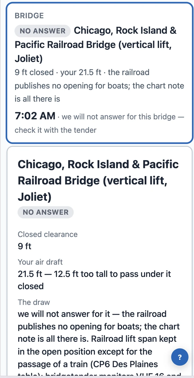
Railroad lifts that publish no opening for boats stay unanswered, by name — we say that rather than guess. A few regulations are written in shapes we cannot hold yet; those bridges show the regulation's own words instead of a time.
Where to find it
Tools → Lock & Bridge Planner. Needs an active trip.
Tools → Lock & Bridge Planner, and Tools → Bridge Clearance Check. Both need an active trip: the plan runs on your boat's profile and your trip's route.
A flight home on the 8th, friends meeting you in Nashville on the 7th. Tell My Trip about a date like that and it lays out the days between here and there at your own speed, counts the locks, and says plainly whether they fit.
My Trip → Dates. Tools → Plan Around Your Dates opens the same card.
Three kinds of date
My Trip → Dates (Tools → Plan Around Your Dates opens the same card). Add a date offers three: Be somewhere by a date, Away from the boat, Start from a place on a date. Add several and they chain.
Fits, Tight, or Does not fit
Your boat's profile and your own habit: 7.5 kn × 6 h, and 14 rest days against 23 travel days in the log.
Grand Haven to DuSable by the 20th: Fits — 95 nm, one lock, 3 travel + 1 rest day, leave by Thu, Sep 17. DuSable to Nashville by October 7th: Does not fit — 676 nm, 13 locks, 21 travel days at 7.5 kn × 6 h, arriving the 10th. The rest days are your own habit, 14 lay against 23 travel in your log.
Two numbers, not one
Four locks carry a tow-queue wait. Counted in the verdict, then said again without them: 17 travel days, arrive Tue, Oct 6 — fits.
Show the days
Depth where we hold one, "depth not on file" where we don't.
Night by night, with depth where we hold one and "depth not on file" where we don't. October 6th is 1.2 nm and 37 hours at Kentucky Lock.
It reads your trip; it never rewrites it
Nothing changes until you press Set as next destination or Make it an away span.
What it cannot do yet
Rest days come from your pace, not the forecast; and it can tell you a date doesn't fit, not yet what would.
Hand a card to another Loop Captain user without it leaving the app. They get an Accept button in their Boat Cards, and their own copy if they say yes.
How it works
Open any card — one you collected, or your own — and tap Share with a Loop Captain user. Type the email they signed up to Loop Captain with. The card appears at the top of their Boat Cards as "Henry shared a card with you," with Accept and No thanks. If they accept, they get their own copy, photos included. Your private notes and where you met stay with you.
Good to know
You need the email they use for Loop Captain — if there is no account under it, the app tells you.
You can withdraw a share until it is accepted.
They will not get an email about it. The card waits at the top of their Boat Cards until they next open the app, so a quick text — "I sent you a card in Loop Captain" — helps.
Loop Captain now plans every day over charted water, from where your boat actually is, at your boat's draft. There is no switch to turn on — it is simply how My Trip works. And the Bahamas banks are on the chart.
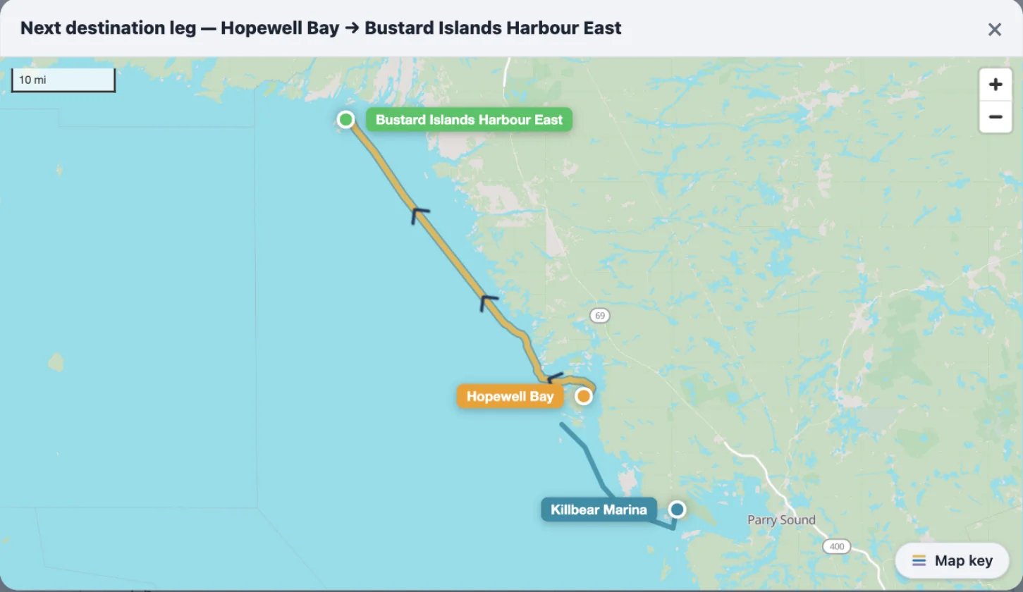
Hopewell Bay to the Bustard Islands: the leg is the water route the router found for this boat's draft — not the Loop line it used to be snapped to.
What changed, and why
Until now, My Trip snapped every leg — the ones you had run and the one ahead — onto the Great Loop route you chose when you set the trip up. Anchor in a cove off that line and your day was drawn back onto the line and measured along it. That was wrong twice over: the line was never the water you were actually on, and the distance was the plan's, not yours. Free cruising fixed it for the captains who turned it on. Now it is simply how every trip works.
Behind this is a planning-grade marine router Loop Captain built this year. It reads the charted depths and finds the route your boat can run at its draft — the Great Lakes, the Atlantic ICW, the Gulf, the inland rivers, the New York and Canadian canals, the St. Lawrence, and now the Bahamas banks. To see exactly where it covers, open the planner and turn on Chart Overlays → Routing coverage.
Planned from where you are
Set a destination and the leg you see is a water route: the channel, the crossing, the canal, drawn over the charts at your draft. Not a line traced along the Great Loop route you picked back in January. If you are in Georgian Bay and want a cove nobody's route goes near, the leg goes there.
The Loop route you built still matters — it decides which way you go where the Loop splits: Tenn-Tom or the Mississippi, the Cal-Sag or the Sanitary, the Okeechobee or the Keys. Those choices steer the water route at the forks and nowhere else.
Every leg says what it was checked against
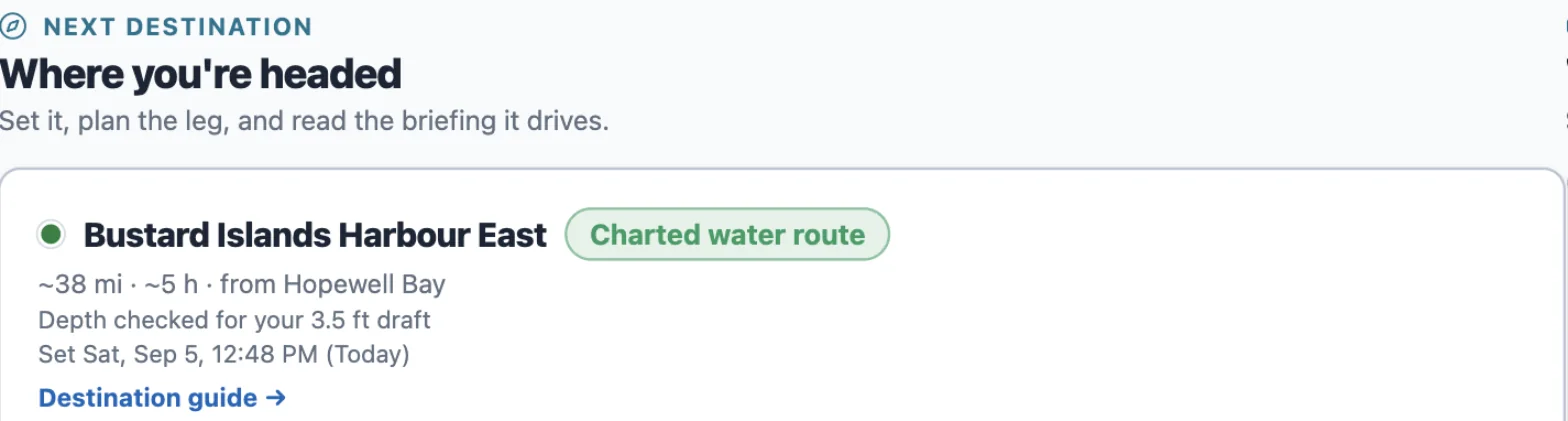
The label next to the destination says what the line is; the line under it says what depth it was checked for.
Next to the destination on My Trip there is a short label: Charted water route, Canal route, River route with the mile you are near, or Drawn Loop line. Under it, what the depth was checked for — "Depth checked for your 3.5 ft draft".
A drawn line means we have no charted water there yet and the leg follows the hand-drawn Loop line — a fair distance, not a depth-checked route. It says so, in those words.
No draft on your boat profile? The leg is planned for a 4 ft draft and tells you that too. Add your draft under Boat and it plans for yours.
The Bahamas
The banks are in: the northwest banks from Bimini and West End, the Abacos, the Exumas, and the south. Depths there are satellite estimates, not surveyed soundings — good enough to plan a day, not to skip the chart. The morning briefing carries the same route line and the same depth note.
What changed on the page
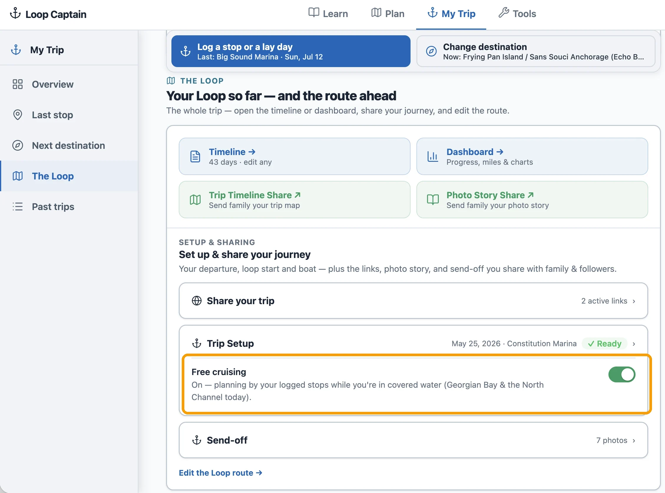
The Free cruising switch is gone from Trip Setup. The trip map shows your past legs and the next one — not a projection of the whole plan ahead. Places near you come first in every search, wherever you are.
Add photos to any day you write up, and share the whole trip as a photo journal the people at home can open without an account. Until today this was something you had to ask us for and wait on. Now it is a button.
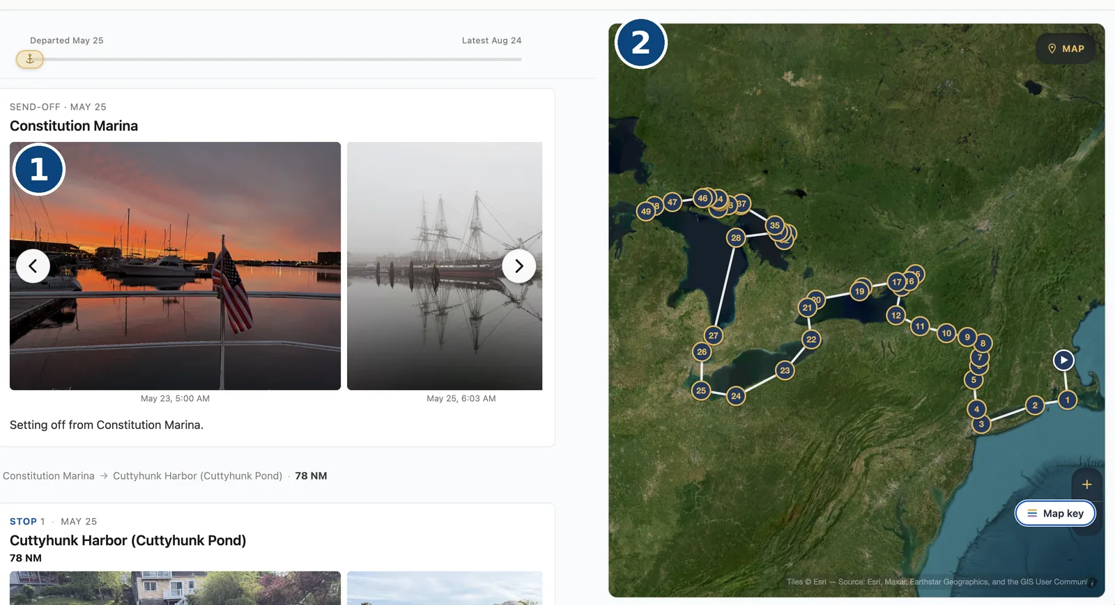
1 — your photos and your words, day by day. 2 — the route on a satellite map. This is the page your family opens, and they need no account to do it.
Turn it on yourself
Open any day in your trip log. Under the story you write for that day there is now a Photos card with a single button: Turn on photos. Press it and the uploader appears where the card was.
None of this is new code meeting the water for the first time. Photos have been quietly running on a handful of boats since May — more than thirteen hundred of them, and over six hundred on one boat alone, across a whole season of writing days up.
Photos that stay with the day
Add up to fifteen photos to any entry, while you are writing the day up or long afterwards, going back to a day you saved weeks ago. Each one takes a description if you want to give it one.
iPhone photos work exactly as they come off the phone — HEIC and all. Every photo is converted in your browser before anything is sent, so a big camera photo does not cost you a big upload on marina wifi. On a phone there is a Take photo button that goes straight to the camera.
Reorder the photos whenever you like, remove one, or move it to a different day if it ended up under the wrong one.
The Send-off
The photos from before you cast off do not belong to any one day — the home marina, the dock party, the people waving you out. They have their own place on My Trip, called Send-off, with a short note of its own, and they open your story ahead of your first stop.
Share it with people who have no account
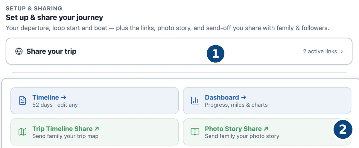
1 — Share your trip is where you make the link. 2 — afterwards, Photo Story Share opens the story you have already shared.
On My Trip, open Share your trip and press Create share link. Copy it and send it to whoever you like — they just open it. No account, no password, nothing to install. Grandchildren included.
What they get is your route drawn on a satellite map beside a scroll of your trip: each stop with its dates, the write-up of the day, and your photos in a row they can tap to fill the screen. Paste the link into a message and it arrives as a picture of your trip rather than a bare address.
Choose the picture they see first
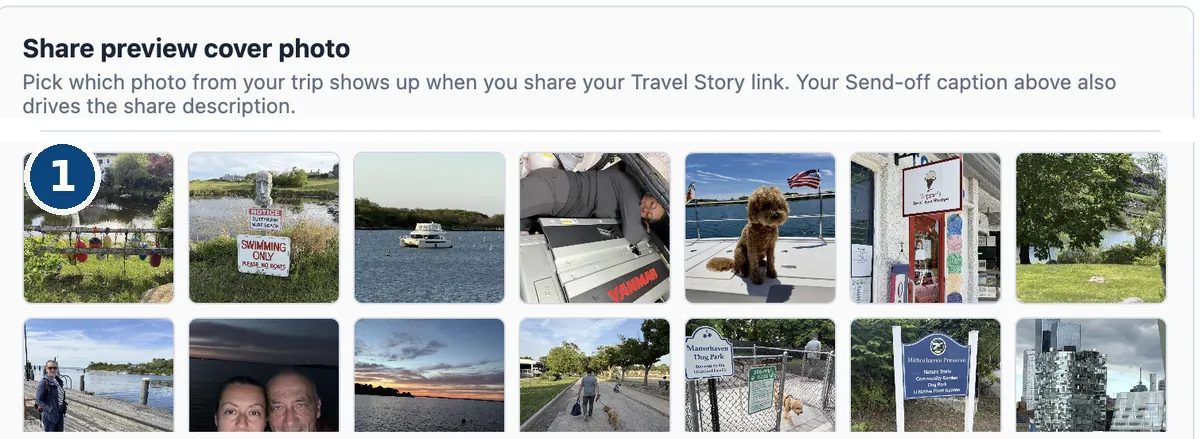
1 — every photo on the trip is in the grid. Tap one and that is the picture your link arrives with.
That photo is not left to chance. Under Share your trip, Share preview cover photo lays out every picture on the trip and lets you tap the one you want people to see first — the sunrise, the dog on the foredeck, whichever one is the trip to you.
Pick nothing and we still choose sensibly: the first Send-off photo, or failing that the first photo of your first day.
And you can take it back
Under Share your trip on the same page, Preview opens the exact page your recipients see, so you can look before you send. Revoke stops the link working straight away. Rotate URL keeps sharing switched on but issues a new address, which is the one you want if a link has travelled further than you meant it to — the old address stops working, and you send the new one to the people you actually meant.
One thing we never show
Cameras write a location into every photo they take. We never put it on the page — not on the story your family opens, not anywhere in the app. Where you have been is yours to tell in your own words, and a photo of a quiet anchorage should not be an address.
Renamed 24 August 2026 — this tool was called the Next Leg Planner when this went out. It is now the Leg Departure Planner: same tool, same link. The Planner went out yesterday and you took to it straight away — suggestions and requests arrived all day from Loopers who already had it out on the water. Thank you. Three of them are live already.
1 — each default now says where it came from. 2 — start from where you actually are, when the fix is fresh enough to trust. 3 — or pick either end yourself.
Both ends are yours
Start from your last stop, from where you actually are, or from anywhere you pick — same for the finish. Before, it only ever read last stop to next destination: the wrong leg once you are under way, and no leg at all if you have not set a destination.
Set both ends, then press Plan this leg. Nothing is worked out until you do.
Position you can trust
It will start from your live position — but only when the fix is recent enough, and it always says how old that fix is.
Reporting goes quiet in poor coverage: the North Channel, Georgian Bay, the St. Marys. It stops rather than reports wrongly, so we wait for a new fix instead of measuring your day from where you were an hour ago. No fresh fix and it falls back to your last stop, and tells you.
Waves now have a memory
A twenty-knot breeze that has just piped up has not built the same sea as one that has blown all night. The Planner now reads how long the wind has actually been blowing at that strength.
The other direction matters more. When the wind eases the old sea keeps running for hours. We do not calculate that — we say it: “Leftover sea: it blew 20–25 kn from the SE until about 09:00…” Expect more than the number shown.
And one small thing
The default start and finish now say where they came from — “last logged stop”, “next destination” — so you can see what the tool assumed before you change it.
Renamed 24 August 2026 — this tool was called the Next Leg Planner when this went out. It is now the Leg Departure Planner: same tool, same link. A new tool on the Tools page. It takes your trip's next leg, splits it into stretches, and shows the wind and the sea for each one at the time you would really be there — then lets you slide your departure and watch the whole day change.
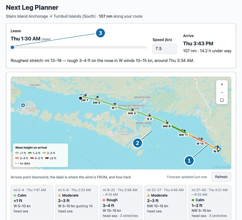
1 — the sea where you’ll be, at the hour you’ll be there. 2 — the wind on each stretch. 3 — slide your departure and the whole day re-reads.
Where to find it
Open Tools, then Leg Departure Planner. Or go straight to /tools/next-leg-planner. There is nothing to fill in — it already knows where you are and where you said you were headed next.
One leg, stretch by stretch
A forecast for "the lake" is not much use on a hundred-mile day. This reads the route your trip actually plans to run, cuts it into stretches, and works out when your boat would reach each one at your cruising speed.
Then it reads that stretch's own wind at that hour, measures the run of open water the wind has crossed to get there (its fetch), and computes the sea from the two. The line on the map changes colour along its length — calm where it is calm, coloured up where it is not — and each stretch carries an arrow saying where the wind is from and how hard.
Above the map, one sentence names the worst of it: which miles, how rough, from which direction, and roughly when.
Slide your departure
The whole point of asking when to leave is being able to try other answers. Drag the departure slider and everything re-reads — the colours on the map, the wind on every card, the arrival time, and the rough patch sliding to a different part of the day. It happens as you drag, because everything it needs is already in front of you.
It also says when an arrival lands outside daylight, using the real sunrise and sunset for that place and date.
Currents, and where we have them
On the Gulf ICW and the rivers, each stretch also says what the current will be doing — 1.8 kn with you, 1.4 kn against you — read at the hour you would be passing it, so it moves with the departure slider like everything else. Tidal current comes from NOAA's own prediction stations for the reaches you will run; river current comes from a live gauge reading, turned onto your course.
Where we do not have it, it says which kind of silence that is. Lake water gets "no tidal current here." Lock-regulated water says so. And the Atlantic ICW says plainly that we have not mapped current stations to it yet — because an inlet current on the east coast is exactly the thing you would want to know, and we would rather tell you we do not have it than quietly show you nothing.
Where every number came from
Under the leg is a panel naming the source of each number: the wind forecast and when it was fetched, how the wave height is computed and from what, which of our own depth-and-shoreline grids measured the fetch and how many stretches sat inside that coverage, and where the clock times and sunset come from.
Where a stretch falls outside that coverage, it shows the wind and declines the wave height rather than guessing — and says so, because a gap in what we have is not the same as calm water.
What it is — and isn't
This is a planning aid, not navigation. Wave heights are for locally generated, wind-driven sea: after a big wind shift, expect leftover chop this does not model. It uses a deep-water model, so shallow water and wind-against-current effects are not in the picture, and currents are reported beside the sea state rather than folded into it.
The leg is capped at 24 hours of running. Rivers and canals show wind but no wave height, because a river is too narrow for a wind sea to build.
Always check the official marine forecast before you leave the dock.
A new planning tool on the Tools page. Enter wind, how far it has blown over open water, and how long it has blown — see wave height, period, steepness, and the largest wave to expect.
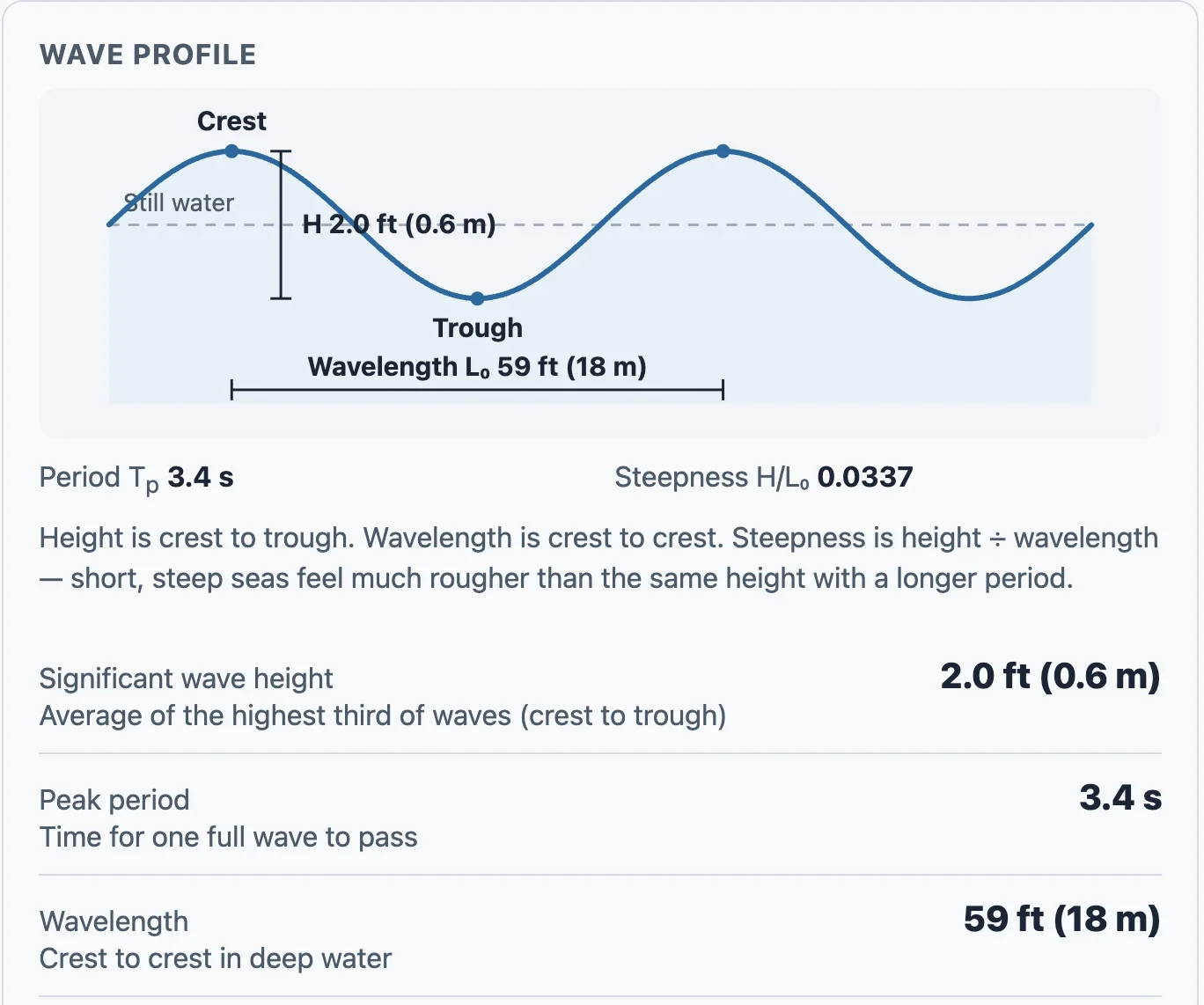
Height, wavelength, and period — labeled on the wave, with the same numbers in the results.
Where to find it
Open Tools, then Sea State. Or go straight to /tools/sea-state.
How to use it
Type the wind speed from the forecast, the stretch of open water the wind has to cross (fetch), and roughly how long the wind has been blowing. Results update as you type — there is no Calculate button.
You'll see significant wave height in feet, peak period, wavelength, steepness, a plain-language sea-state label, and the largest wave you might meet in a few hours of that sea. A simple wave diagram labels crest, trough, height, and wavelength with the same numbers.
What it is — and isn't
This is a planning estimate for deep, open water and local wind-driven sea. It does not account for shallow water, wind against current, or swell from a distant storm. Always check the official marine forecast before you leave the dock.
Collecting the cards was the first half. Now you can see everyone you've met on a map of the Loop, call or text them from the card, find anyone however you half-remember them — and hand back a card of your own.
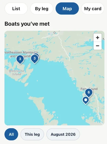
A season of docktails, as a picture of your Loop.
Everyone you've met, on the map
Boat Cards now has a Map. Every card sits where you met that boat, so a season of docktails becomes a picture of your Loop. Meet six boats at the same marina and they share one pin with a 6 on it — tap it and all six are listed with their cards, their names and the day you met.
Filter to the stretch of water you're cruising now, or to this month, when you want the map to answer a narrower question.
Text them back
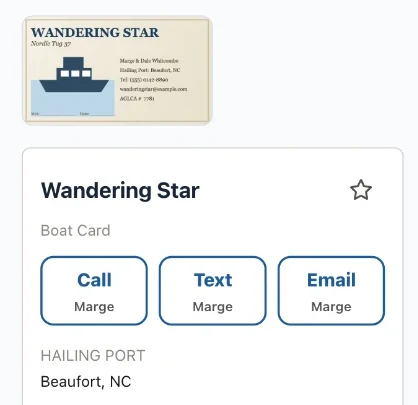
Call, Text and Email, on the card itself.
The whole point of keeping a number is using it. Card faces now have Call, Text and Email buttons that hand straight off to your phone. Only the ones the card actually has show up, and the first name sits under each button so you know who you're about to ring.
When a card has two people with different numbers, tapping asks which one — as a plain list, not a guess.
Find anyone, however you remember them
Search now matches every word you type, in any order, anywhere on the card. "Sound big" finds Big Sound Marina. "Gild knot" finds Knot Supersonic through the owner's surname. Half a word is enough.
You can star the boats you'll want again, and the ones you starred sit at the top alongside a row of who you met most recently.
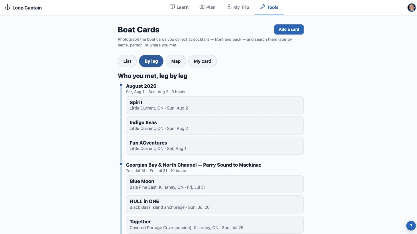
Who you met, leg by leg
Your cards, grouped by the water you were on.
A By leg view groups your cards under the stretch of the Loop where you met them — the Trent-Severn crowd, the North Channel crowd — newest first. Cross wakes with the same boat twice and it says so, and shows up under both legs.
Somewhere you've tied up before
Dock where you've collected cards before and Boat Cards says so quietly: you've met two boats here before, with their names and when. Tap through to their cards. It's a line in the app when you go looking — never a notification while you're docking.
A card of your own
Someone hands you a card and you've got nothing to hand back. Set up My card once — your boat, your crew, your numbers — and you have two ways to pass it on: copy your details as plain text to paste into a message, or send the contact straight into their phone's address book.
It lives behind a My card button on the Boat Cards screen, out of the way until you need it.
Better captures, smaller photos
Photographing a card got sharper in every sense. The card's corners are found for you and the photo is flattened square-on, so a picture taken at an angle still reads cleanly — nudge a corner if it needs it. Cards carrying a QR code have it read automatically. And stored photos dropped from roughly a megabyte a side to under a tenth of that, with no loss you'd notice on a phone.
The card is also saved the moment you press Save this card, so nothing can be lost by closing the app mid-review. Anything still to check wears a badge until you confirm it.
Put it on your home screen
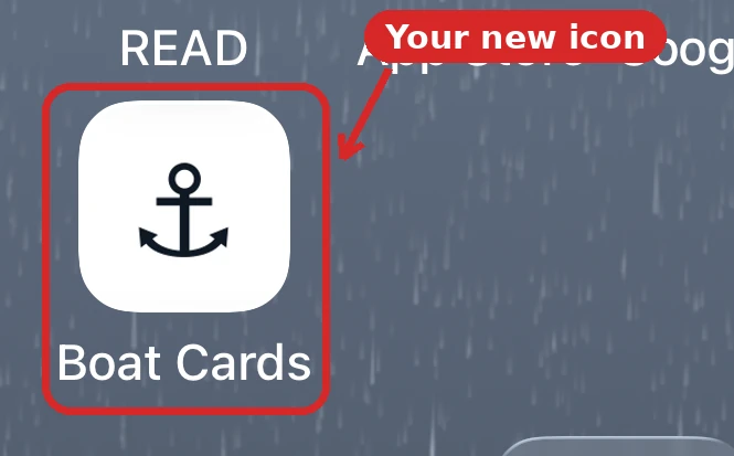
An anchor on the home screen — Boat Cards, one tap away.
Boat Cards can live on your phone's home screen as its own icon, next to your other apps. Tap the anchor and you land straight in your cards — full screen, no browser bar, no Loop Captain home page to get past. It feels like a dedicated app because at that point it behaves like one, which is what you want when the cards are coming out at the dock and you're holding a drink in the other hand.
It takes about a minute. On an iPhone it has to be Safari, and there is one odd step you can't skip — the guide walks through it with pictures.
When you edited a card, the Save button could sit below the bottom of the screen — so it was possible to make changes, leave, and lose them without being told. Save now stays on screen wherever you scroll, and leaving with unsaved changes asks first.
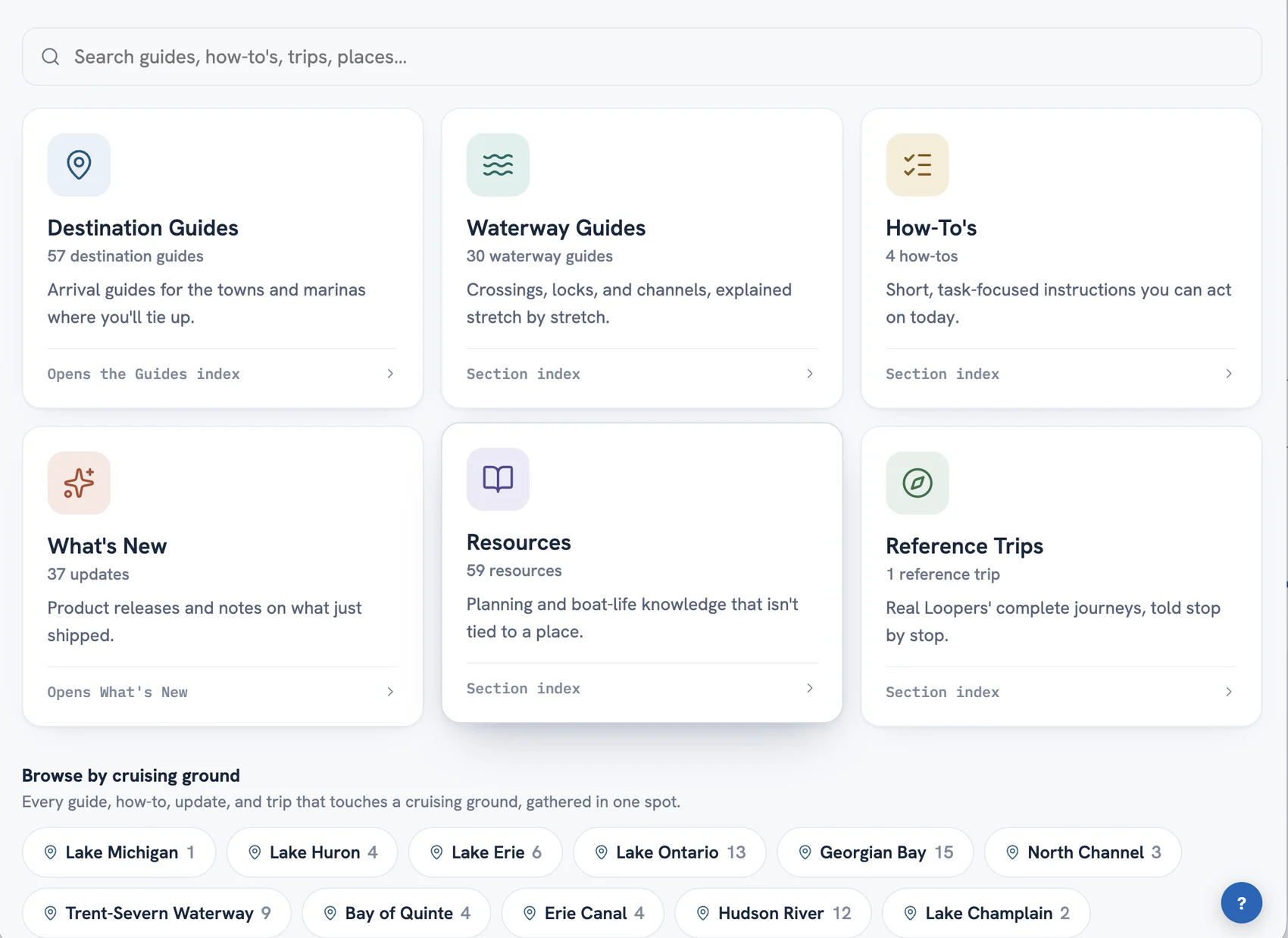
The Learn tab is now the Library: the same guides and knowledge, reorganized into six clear shelves — with a clickable map of the waterways, everything cross-linked by cruising ground, and a real Loop you can explore two ways.
The Library — six shelves, one home.
Six shelves instead of one long page
Learn had grown into one long page trying to hold everything. The Library gives each kind of knowledge its own shelf: Destination Guides for the towns and marinas where you'll tie up, Waterway Guides for the crossings and locks between them, How-To's for quick tasks, What's New for what just shipped, Resources for the planning and boat-life knowledge that isn't tied to a place, and Reference Trips for complete real journeys.
Every shelf has its own landing page, so you can send someone straight to the waterway guides or the resources shelf with a plain link.
Browse by cruising ground
Nineteen cruising grounds — Georgian Bay, the Trent-Severn, the Chesapeake, the Keys, and the rest — now act as the Library's spine. Pick one and you get everything Loop Captain has about those waters, gathered in one list: the destination guides, the waterway knowledge, the updates, and the trips that passed through.
The waterways, on a map
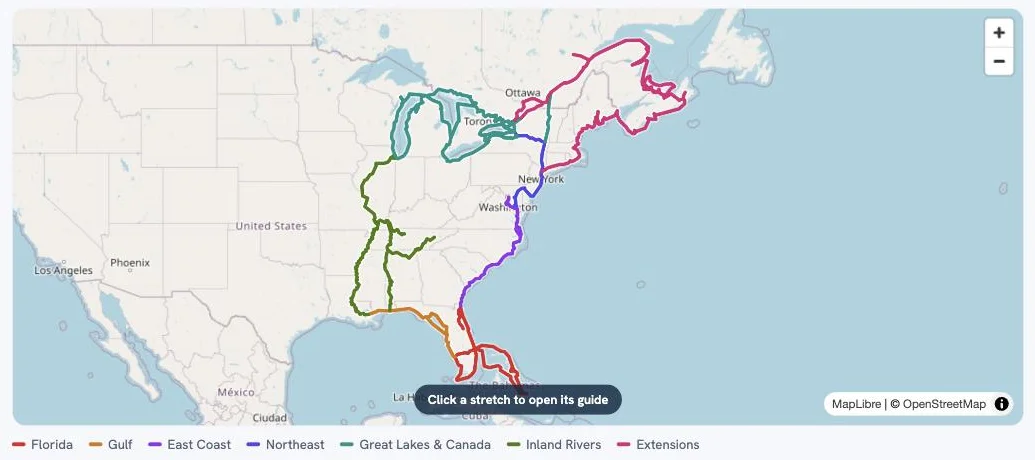
Every stretch of the Loop, colored by region — click one and its guide opens.
The Waterway Guides shelf opens with the Loop drawn as a map — every stretch colored by region, from the Erie Canal to the Gulf crossing to the Down East extension. Click any stretch and its guide opens. It's the fastest way to answer the question every Looper starts with: what's the water ahead actually like?
One trip, told two ways
One real Loop, two ways in — the photo story and the trip map.
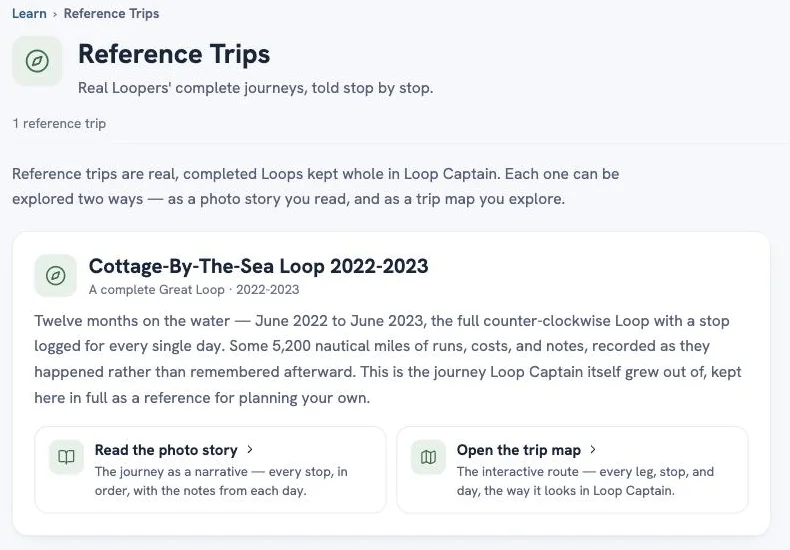
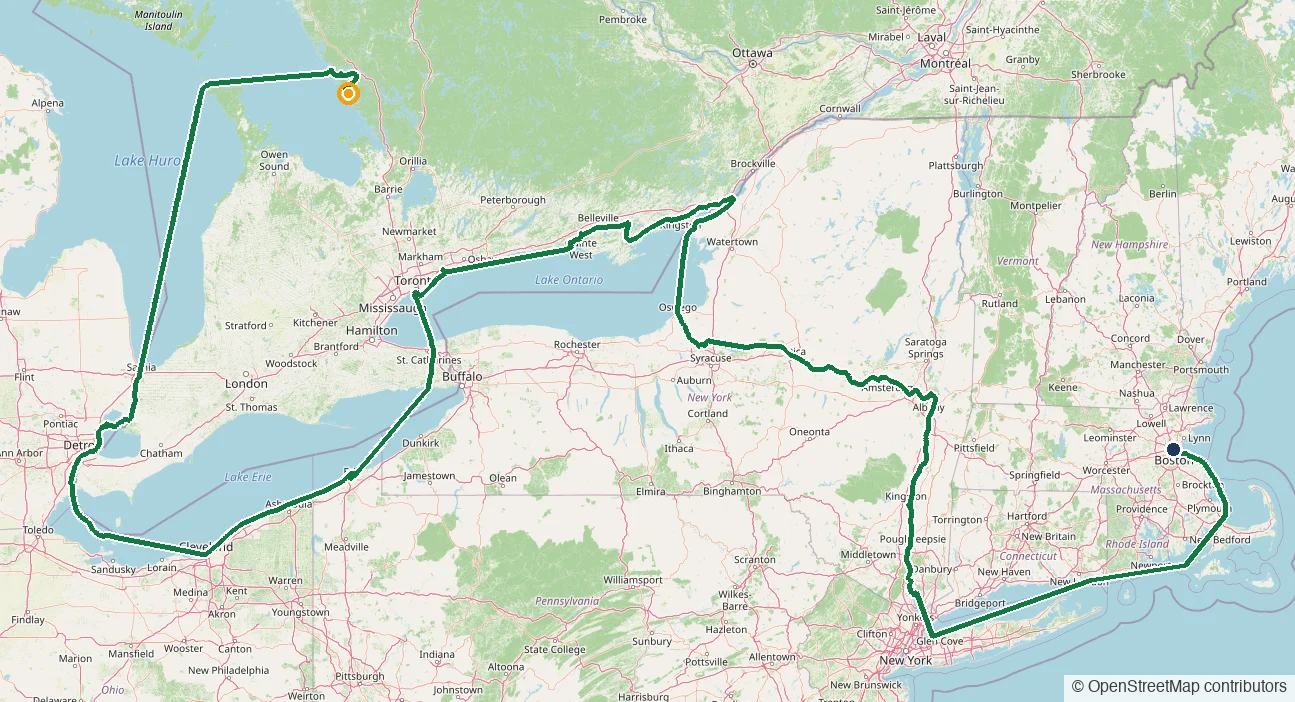
The Reference Trips shelf holds the Cottage-By-The-Sea Loop 2022-2023 — a complete Great Loop with a stop logged for every single day of a twelve-month, counter-clockwise trip. You can read it as a photo story, stop by stop, or open the trip map and explore every leg and day the way it looks inside Loop Captain. More reference trips are coming; real trips are some of the most useful planning material there is.
Little things that matter
Type is bigger and lines are more comfortable to read. Links open in the tab you're in, so the back button always brings you home. Press / anywhere in the Library to jump to search. Destination guides now live at loopcaptain.com/guides/ (old links redirect automatically). And What's New posts — including this one — now have real pages of their own you can share.
Lake Erie joins the router — and with it Lake St. Clair and the Detroit and St. Clair rivers, so real water routes now flow between Erie and Huron the way boats actually travel.
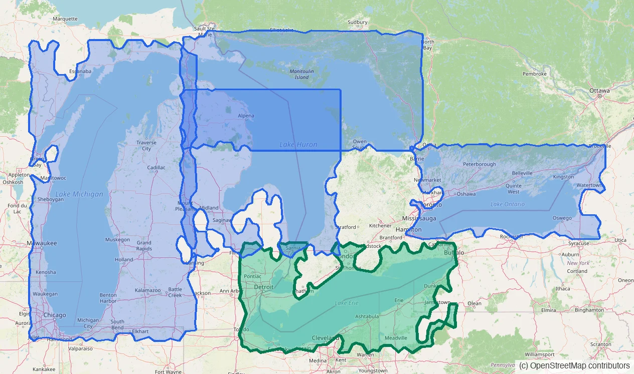
Covered water at a glance — the new Lake Erie & Lake St. Clair region highlighted.
The Loop's last lake
Pick a destination anywhere on Lake Erie — Buffalo, Presque Isle, Cleveland, the Bass Islands, Toledo, Port Stanley, or along Long Point — and the planner answers with a real water route: around the shoals, through the charted channels, honest about depth.
Coverage runs the whole lake, both shores, plus Lake St. Clair and the rivers on either side of it.
Through the rivers to Lake Huron
Routes now travel between Lake Erie and Lake Huron the way your boat does: up the Detroit River, across Lake St. Clair, and up the St. Clair River past Port Huron. It's the second river connection in the network, joining the Straits of Mackinac — so covered water now runs continuously from Buffalo to Chicago.
Honest at the edges
The Welland Canal is lock water — your planned route carries you between Erie and Ontario, as it should. And in the St. Clair delta, the small-craft channels the charts can't guarantee at your draft are refused honestly rather than guessed.
See exactly where routing lives: open the planner's Chart Overlays and switch on Routing coverage.
The line behind your boat used to be the planned route — fine while you followed it, wrong the moment you didn't. Now every day of your trip is drawn from the strongest record of that day's run, stop to stop.
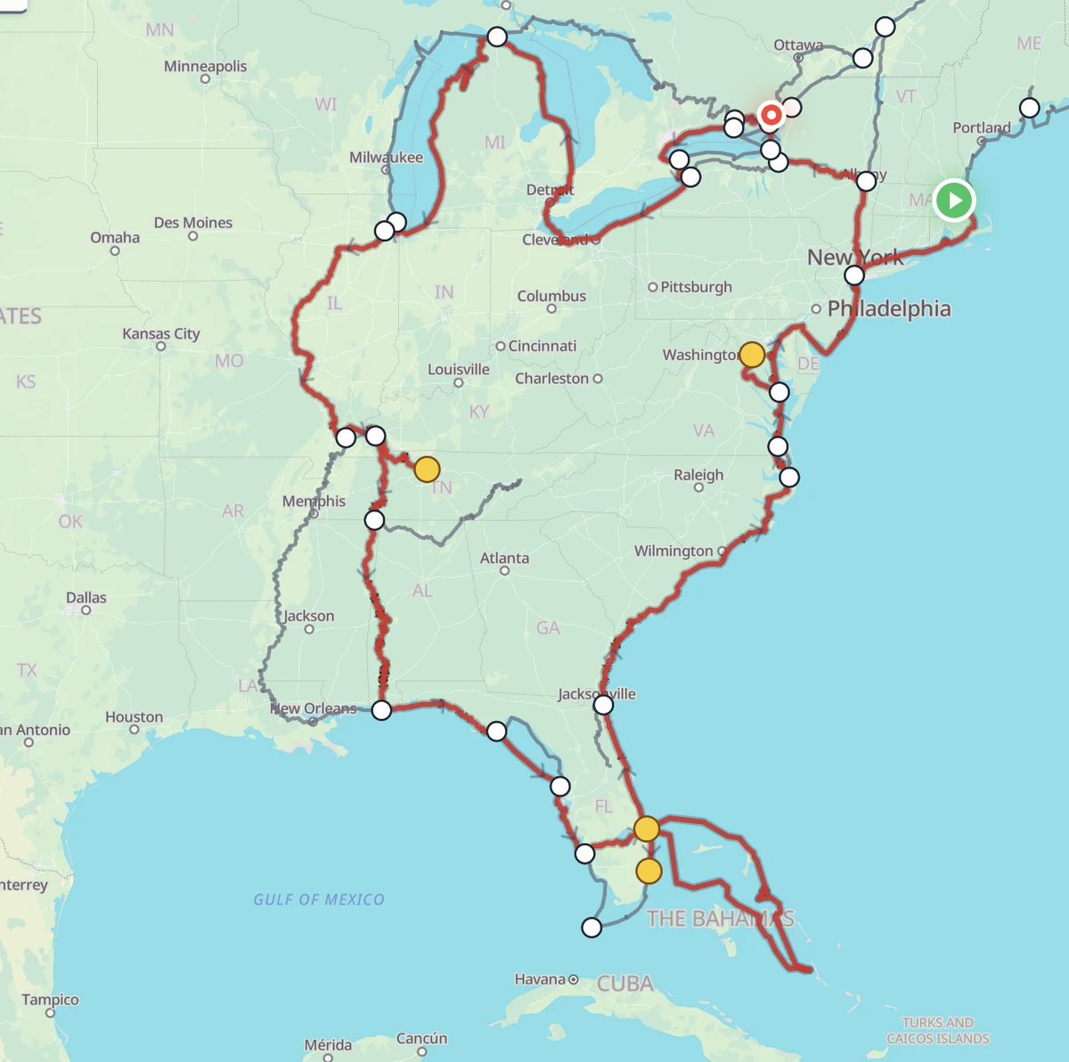
One captain's real track — every day rebuilt from the best record of that day.
The best evidence wins, day by day
For each travel day, the map now looks for the truest line between the two places you actually stayed: your boat's own tracker first, then your Nebo track, then a route you drew by hand, then the route you were following that day.
Anchored at both ends to your real stops — the line visits every place you visited.
Honest when the record is thin
No track, no drawn line, no route that reaches that day's stop? The map says so: a simple dashed line straight between the two stops, rather than a confident guess.
And while Free cruising is on, the "loop ahead" line stays off your maps entirely — projecting a route you're not following helps no one.
Everywhere your trip shows
The same truthful track now appears on My Trip's map cards, the Trip Timeline, the Trip Map page, and the pages you share with family — all drawn from one record, so they always agree.
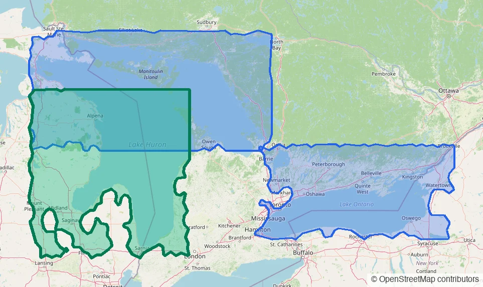
Real water routes now cover the Port Huron corridor, Saginaw Bay, and the open lake up to Georgian Bay — and a new map layer shows you exactly where automatic routing is available.
Covered water at a glance — the new Lake Huron region highlighted.
New water under the router
Pick a destination along southern or mid Lake Huron — Port Huron up the Michigan shore, into Saginaw Bay, or across toward Tobermory — and the planner now answers with a real water route: around the shoals, through the charted channels, honest about depth.
That makes three connected regions of covered water: Georgian Bay & the North Channel, Lake Ontario & the Thousand Islands, and now Lake Huron.
See the coverage, don't guess it
Open the planner's Chart Overlays and switch on Routing coverage. Shaded outlines show exactly where automatic water routing is available today — so when a route comes back as a straight line, you'll know whether you're outside covered water or truly off the network.
Every Looper trades boat cards, and every Looper ends up with a stack no one can search. Now your phone turns that stack into a crew list — who you met, their boat, their contacts, and where on the Loop you shook hands.
Two photos, whole stack
Lay the cards out, take one photo of the fronts and one of the flipped backs. Each card is read for you — boat name, home port, the people aboard (kids and pets included), phones, emails, AGLCA number, even handwritten notes. A quick review screen lets you fix anything before it saves.
It remembers where you met
Every card automatically records the marina or anchorage and the date from your trip — so later you can jump straight to the facility page or open the spot in your maps app.
Search like you think
“That couple from the fuel dock” works: search by boat, name, marina, town — even the waterway where you met.
Where to find it
Tools → Boat Cards, built phone-first. Use the camera or your photo library, drag a photo in from Messages, and crop each card right on the screen. Available to everyone starting today.
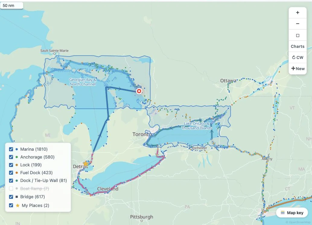
A few days ago, real-water routing covered Georgian Bay and the North Channel. It now covers Lake Ontario and the Thousand Islands too — and in both regions, US harbors route on real charted depths.
New water: Toronto to Brockville
The whole Canadian Lake Ontario shore now routes on charted depths and your boat's draft — Toronto, Hamilton and the Niagara shore, the Bay of Quinte, Kingston, and the Thousand Islands down to Brockville, including the island channels.
US harbors carry real depths now
Depth data from US harbor charts joins the Canadian soundings in both regions. On Lake Ontario that means Oswego, Sackets Harbor, Henderson, Chaumont Bay and Cape Vincent; on northern Lake Huron it means Mackinac Island, Mackinaw City, Cheboygan, DeTour Passage, Drummond Island and Rogers City. Charted rocks, wrecks and obstructions are kept out of the line the same way surveyed rock is on the Canadian side.
Open-lake US water still routes with unverified depths — and the map says so, plainly.
See exactly where it works
On the planner map, open Charts and turn on “Routing coverage”: the shaded shapes are the waters where routes follow real depths.
Held to a captain's standard
Every release of the routing engine is checked against a growing library of real cruising routes drawn by hand on marine charts — 44 of them now, from harbor hops to a 122-nautical-mile open crossing.
A cluster of planner improvements shipped this week — the first look at any route lands in seconds, your boat shows where it actually is, and the map explains itself better.
Water routes in seconds
The first look at a brand-new route now lands in a few seconds — including the island-maze anchorages that used to take fifteen or more. Routes you've viewed before stay instant. And when you're free cruising, every next-stop preview answers with the real water route first.
Your boat, live on the planner
Your boat's current position now shows on the planner map, so planning starts from where you actually are.
Every stop, always
The stops list and the map's stop markers now show every facility, regardless of which routes you have selected — nothing hides just because it's off today's line.
Names on the water
Island, bay and channel names from the US and Canadian government name registries now label the map, on by default — bigger and easier to read, so the chart talk in guides and briefings matches what you see.
A Loop Start that levels with you
Setting your Loop Start now searches every marina — and if a spot can't start your loop, it tells you why and names the nearest route instead of silently refusing.
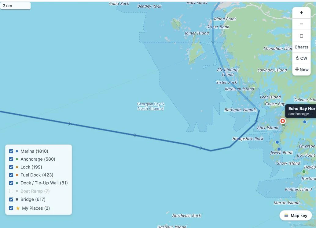
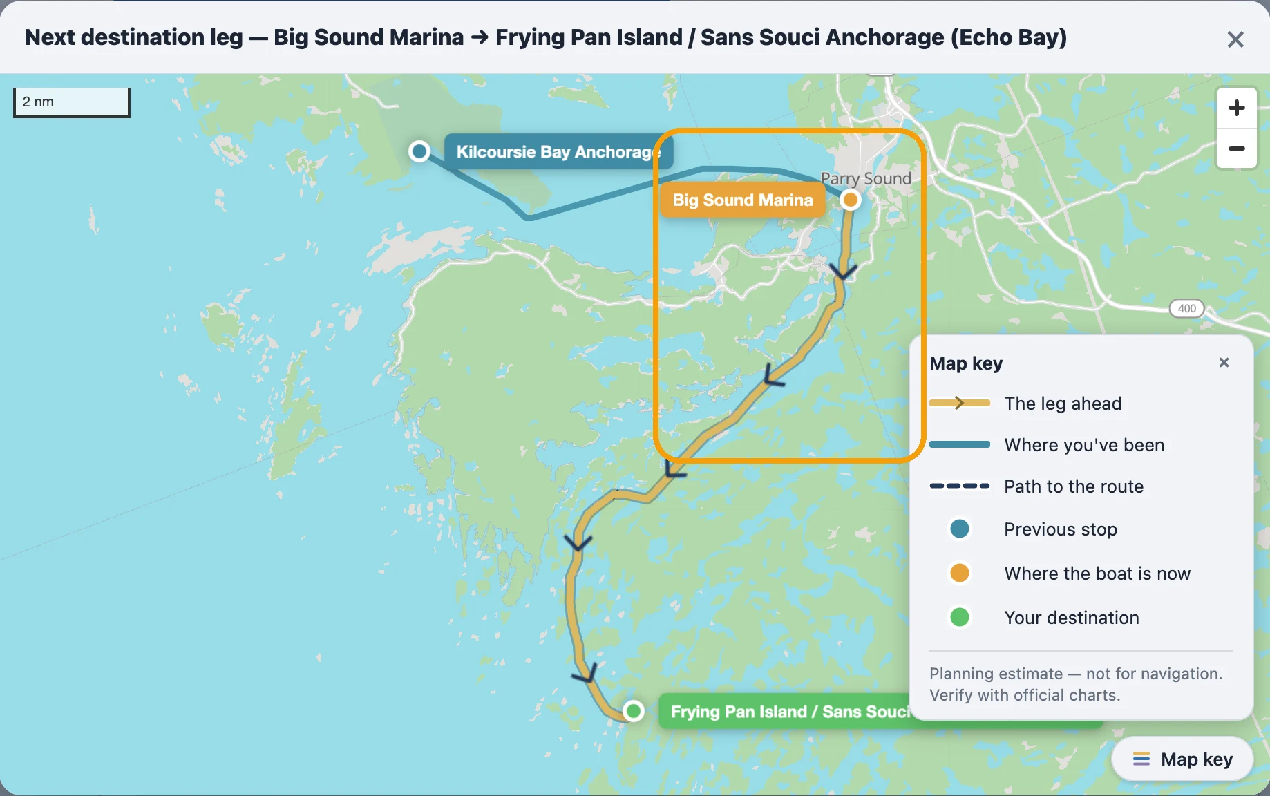
When you set your next stop in Georgian Bay or the North Channel, the route you see now follows the actual water — charted depths, real channels, your boat's draft — down to the small-craft channel behind Parry Sound.
Routes that respect your draft
The line is computed from Canadian Hydrographic Service depth data plus the same coastline the map draws — it never crosses land, and it never sends you through water shallower than your draft plus a safety margin.
The narrow channels count
Mapped channels as tight as a few boat-lengths now route. Big Sound Marina to Echo Bay is about 12 nm through the inside channel — earlier it drew about 18 nm around the outside.
Honest to the last foot
Where charted depth runs thin near a dock or anchorage mouth, the solid route stops at the last water it can vouch for, and a dashed line covers the final approach — that part's yours by eye.
Fast the second time
A route you've looked at before comes back instantly.
Where it applies
This applies to Georgian Bay and the North Channel — everywhere else still uses the standard route.
From Georgian Bay through the Trent-Severn corridor to the Thousand Islands — the guide library now covers dozens of harbors, anchorages and canal towns Loopers actually stop at, each researched dock by dock.
What a guide gives you
A facilities table (transient slips, fuel, pump-out, power, VHF), anchorages, what's ashore, and local knowledge — researched dock by dock, not scraped.
Where they cover
Georgian Bay and the Trent-Severn corridor, now reaching east to the Thousand Islands on both shores of the border — including the crossing pair Rockport, ON and Alexandria Bay, NY, with real customs phone numbers and the CBP ROAM app.
One map for all of them
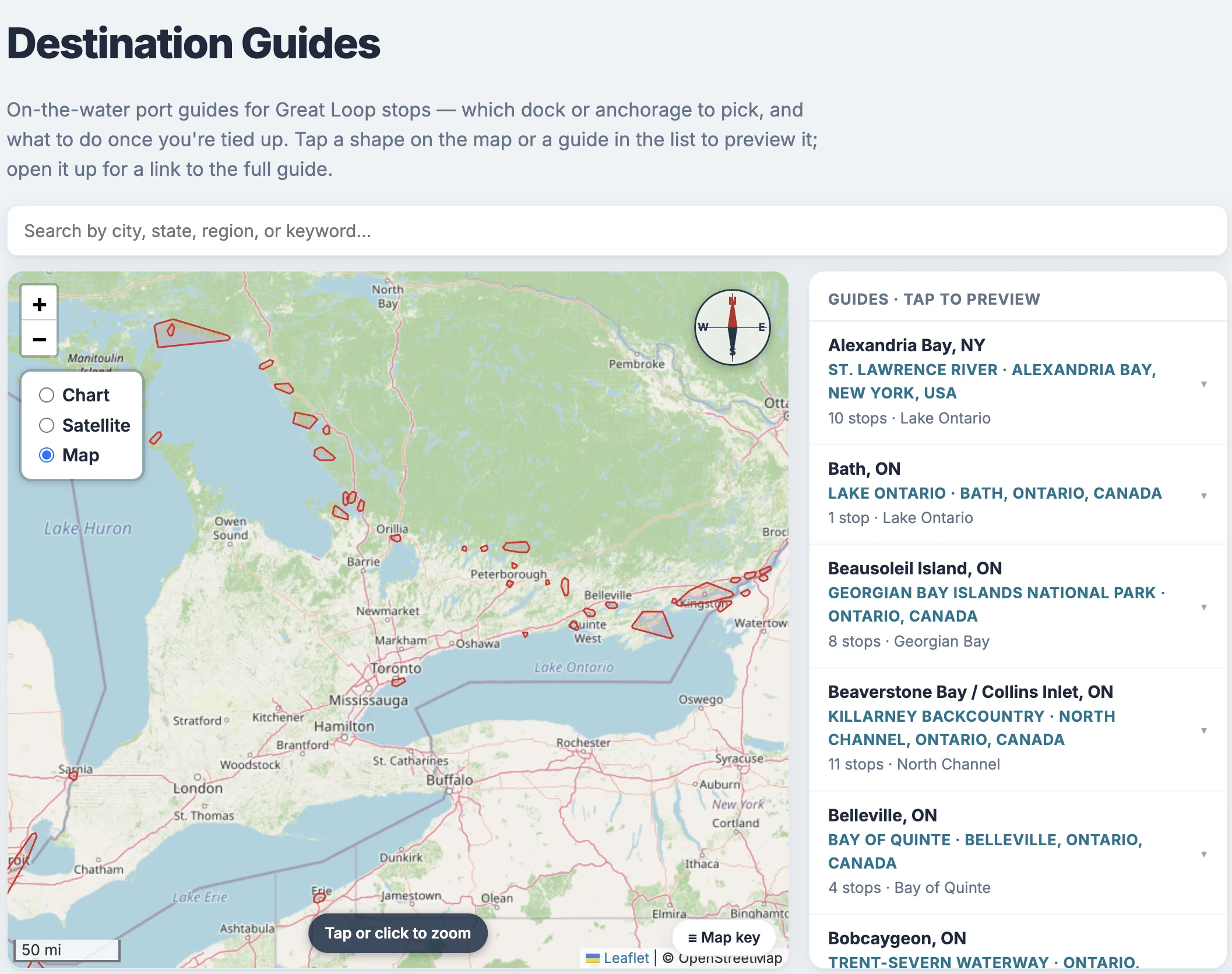
Every page on Loop Captain links to it: scroll to the footer and tap "Destination Guides" (loopcaptain.com/guide) to open the all-guides map — every guide's coverage area drawn at once. Tap a shape, or search by city or region, to preview a guide; open it for the full page.
Your briefing knows
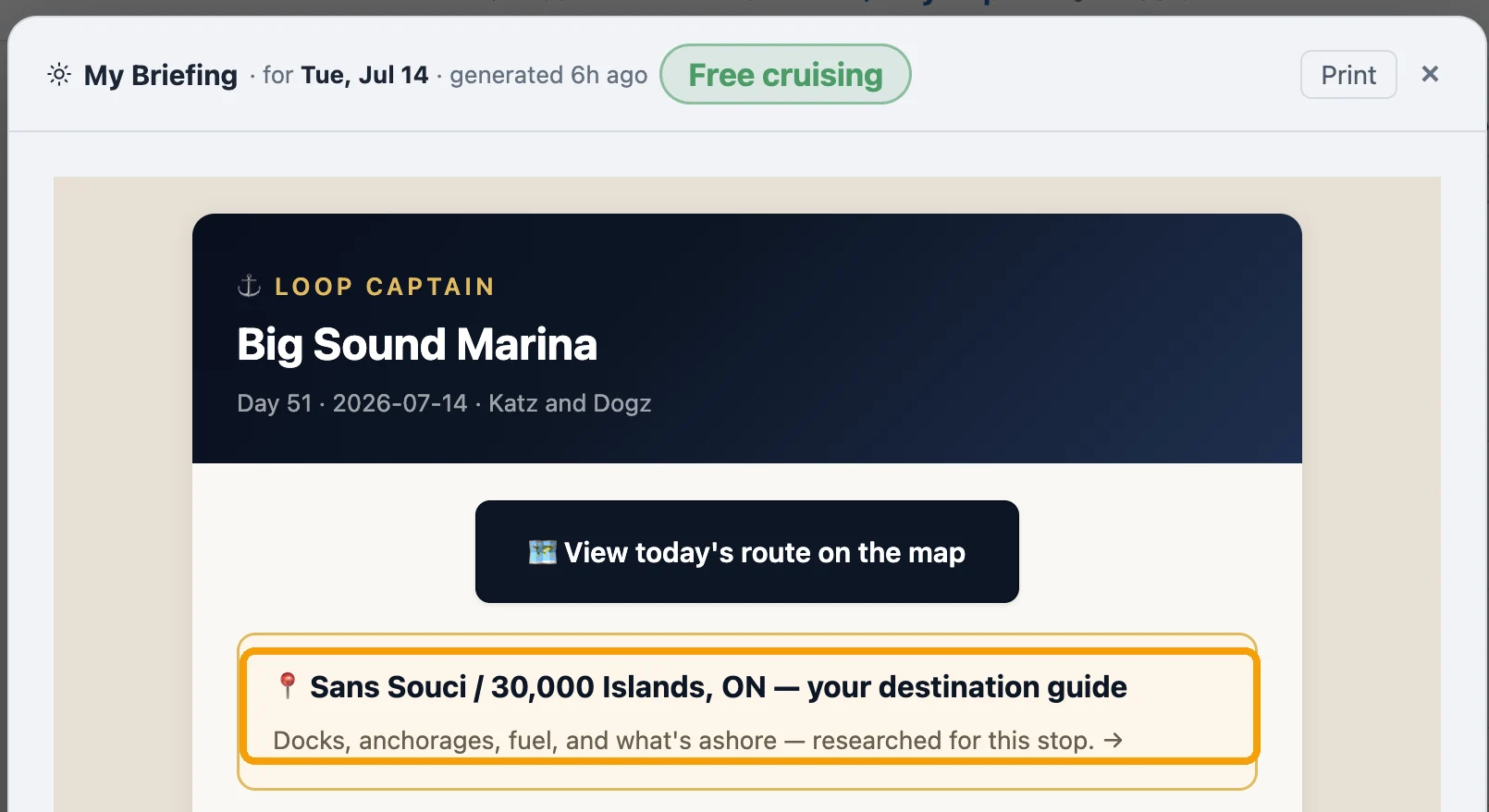
When your next stop is in guide territory, the morning briefing carries a gold card with a direct link straight to that stop's guide — no searching required.
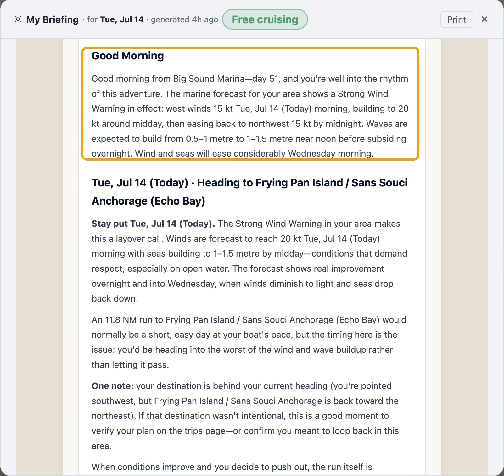
Briefings on Canadian waters now carry Environment Canada's actual marine forecast for your area — the same winds, waves and warnings the Coast Guard reads — and when no forecast exists for where you are, the briefing says so instead of guessing.
Where it applies
Georgian Bay and North Channel marine areas. Outside those areas, if no forecast is available, the briefing tells you plainly instead of inventing calm.
Flip one switch in Trip Setup, and Loop Captain works the way you actually cruise Georgian Bay and the North Channel: no fixed itinerary, no phantom plans — just where you are, where you're headed next, and honest numbers.
The switch
Trip Setup has a "Free cruising" toggle, active only inside covered water.
Days without a destination stay honest
No invented daily-target projections — the app says you're staying put until you say otherwise.
Arriving resets the day
Logging an arrival clears your next destination, with a visible note, so every day starts from where you actually are.
Search near the boat
While free cruising, searching "fuel" or "anchorage" finds places near your position, not along a route.
Maps that match the mode
Maps show past legs and the next leg, not a future itinerary you've deliberately left. A "Free cruising" tag shows on the day card, the briefing, and the picker.
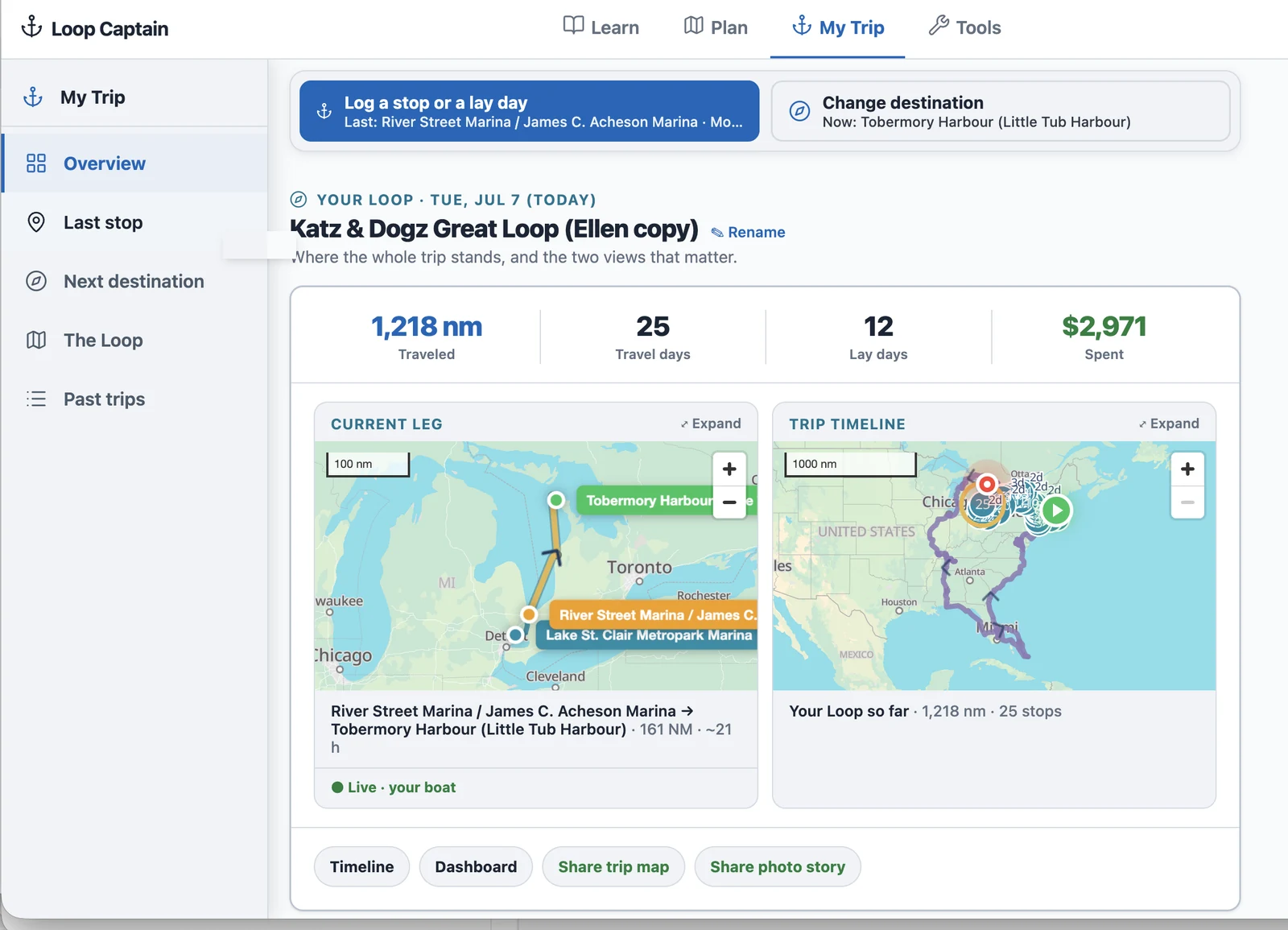
My Trip is the screen most Loopers open every morning, and it had grown into a stack of cards that didn't always agree with each other. We gave it a top-to-bottom rewrite: one connected story from today, to your last stop, to what's next — same actions you already know, just easier to find and read.
One story, top to bottom — the whole trip at a glance.
One page, five sections, a rail to jump around
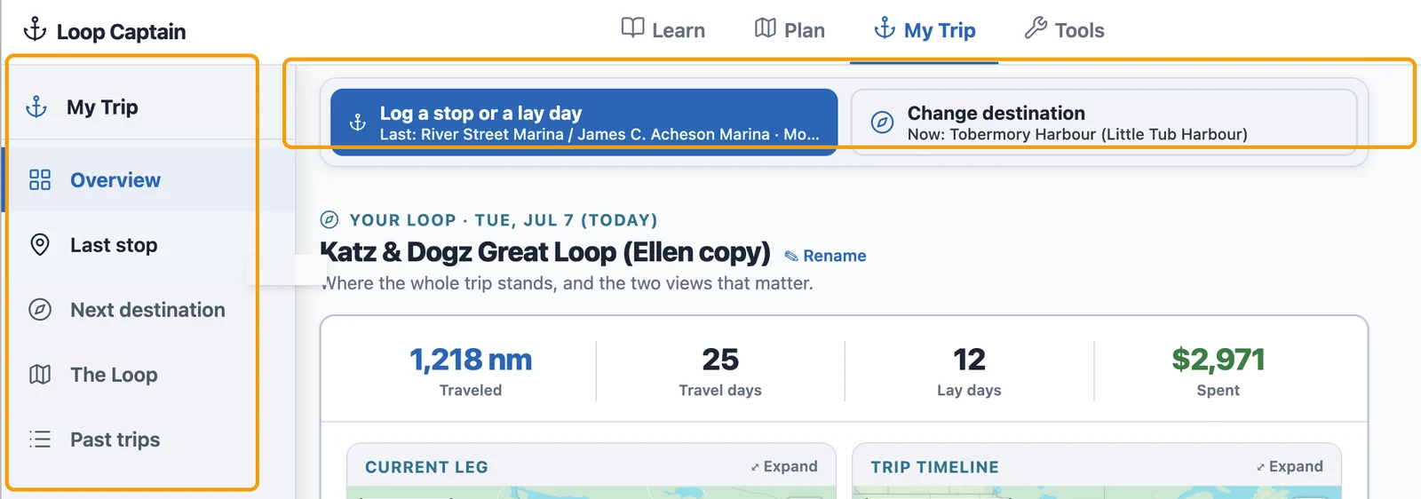
Jump to any section from the rail; the two main actions are pinned at the top, always.
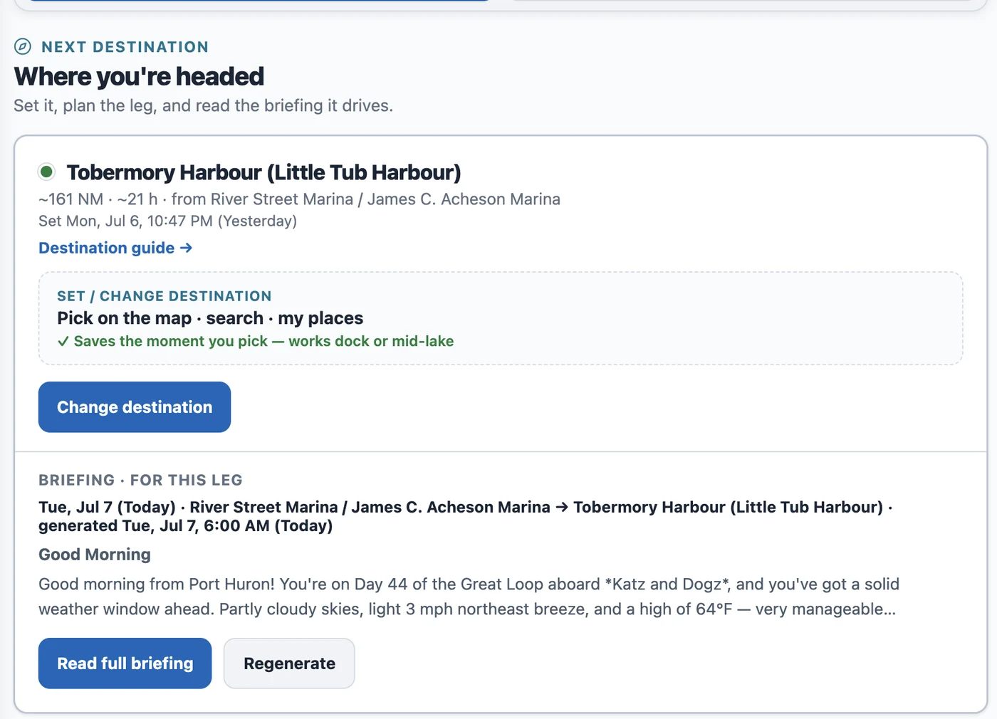
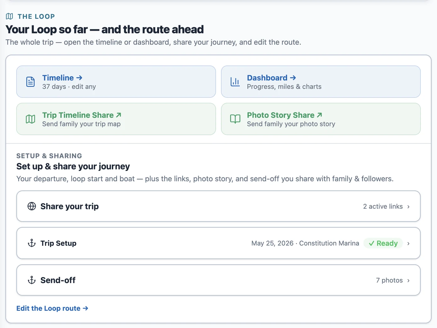
The page now reads top to bottom as one story: Overview, Last stop, Next destination, The Loop, and Past trips. A rail down the left side lists all five — tap any of them to jump straight there, and it highlights as you scroll so you always know where you are. Log a stop (or a lay day) and Set — or change — your next destination sit in a pinned bar at the very top, on every section, so you never have to hunt for them.
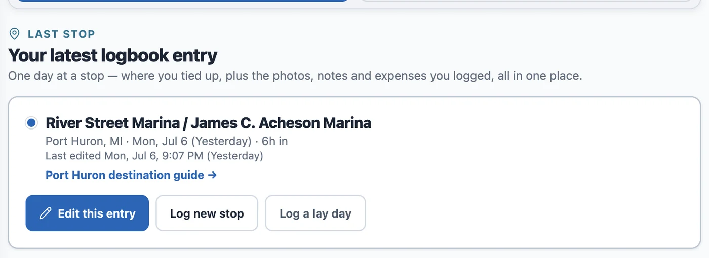
Your last stop, at a glance
The Last stop section is a clean receipt of your most recent log entry — the stop's name, when you logged it, a photo strip, your note, and what you spent — with a straight line back into the log form if you want to edit or add more.
Last stop and next destination — two different questions, kept apart
Setting where you're headed next now has its own section — it doesn't share a box with logging where you've been.
Logging where you tied up and setting where you're headed next used to blur together, and that mix-up was one of the most common points of confusion we heard about. They're different questions, so now they live in different places: Last stop is your logbook; Next destination is its own section, with its own way to pick a spot — map, search, or My Places — and the leg briefing for that choice right below it, so you can see the run before you commit to it.
The Loop: everything else, one tap away
The Loop is the rest of your trip in one place: the Timeline and Dashboard views, the links you send family (trip map, photo story), and the Trip Setup and Send-off cards. They used to live scattered under separate, oddly named sections — now they're one tap from the rail.
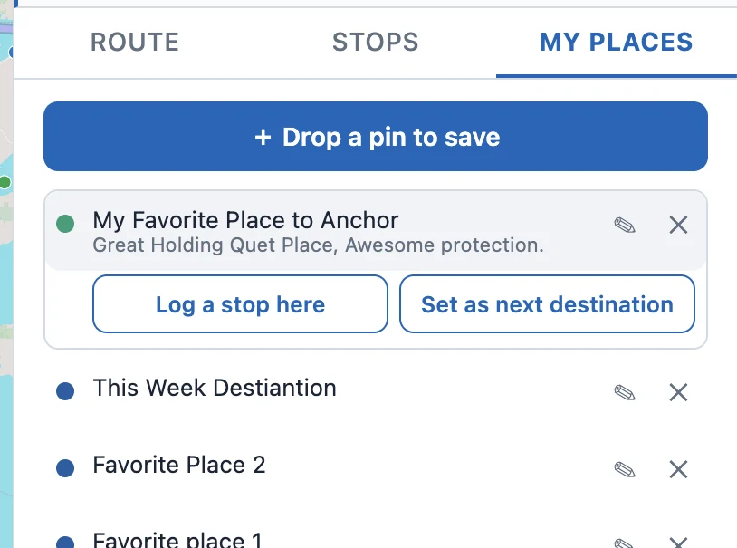
The map only ever showed our catalog of marinas, anchorages, and locks. Now you can save your own places too — a friend's dock, a quiet anchorage you found, a fuel stop worth remembering — drop a pin, name it, and it rides along on every trip.
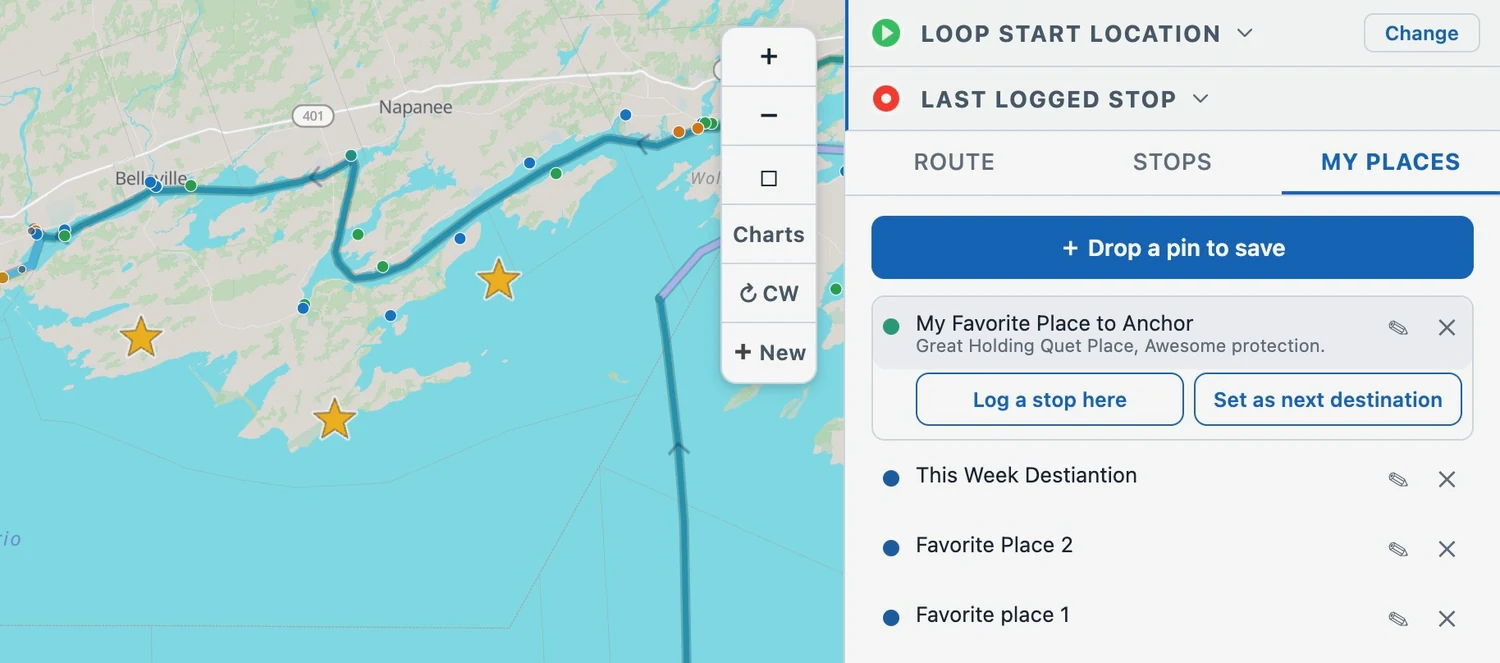
Your own places, saved as gold stars on the map and reusable on every trip.
Why we added it
Loopers pass places that aren't in our catalog all the time — a private dock, a cove you found yourself, the spot you want to come back to. The catalog is shared and curated, so it's not the place to keep your own marks. My Places is: a personal library that's yours alone and shows up on every trip.
Save a spot two ways
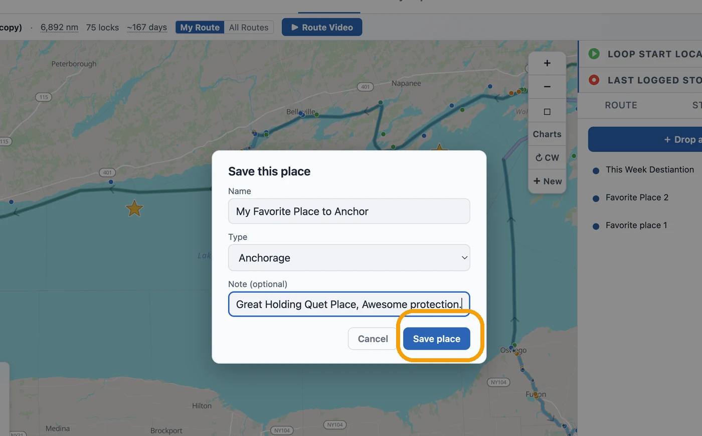
Drop a pin, give it a name and type, add a note, then tap Save place.
Open the My Places tab in the planner and tap + Drop a pin to save, then tap the map where you want it — give it a name, pick a type, add a note, and tap Save place. Already looking at a marina or anchorage on the map? Open its card and tap ★ Save to My Places.
They show up as gold stars on the map
Every saved place is a gold star on the map, sitting on top of our catalog dots so it's easy to spot. A My Places row in the map legend turns your stars on and off whenever you want a cleaner view.
Use a saved place — log it or head for it
Tap a saved place to log a stop there or set it as where you're heading next.
Tap a star on the map (or a row in the list) to open it. From there you can Log a stop here or Set as next destination — and when you're setting tonight's stop or tomorrow's destination, your saved places show up right in the search, so you can pick one without hunting for its pin. Edit a place's name, type, or note, or remove it, anytime from the list.
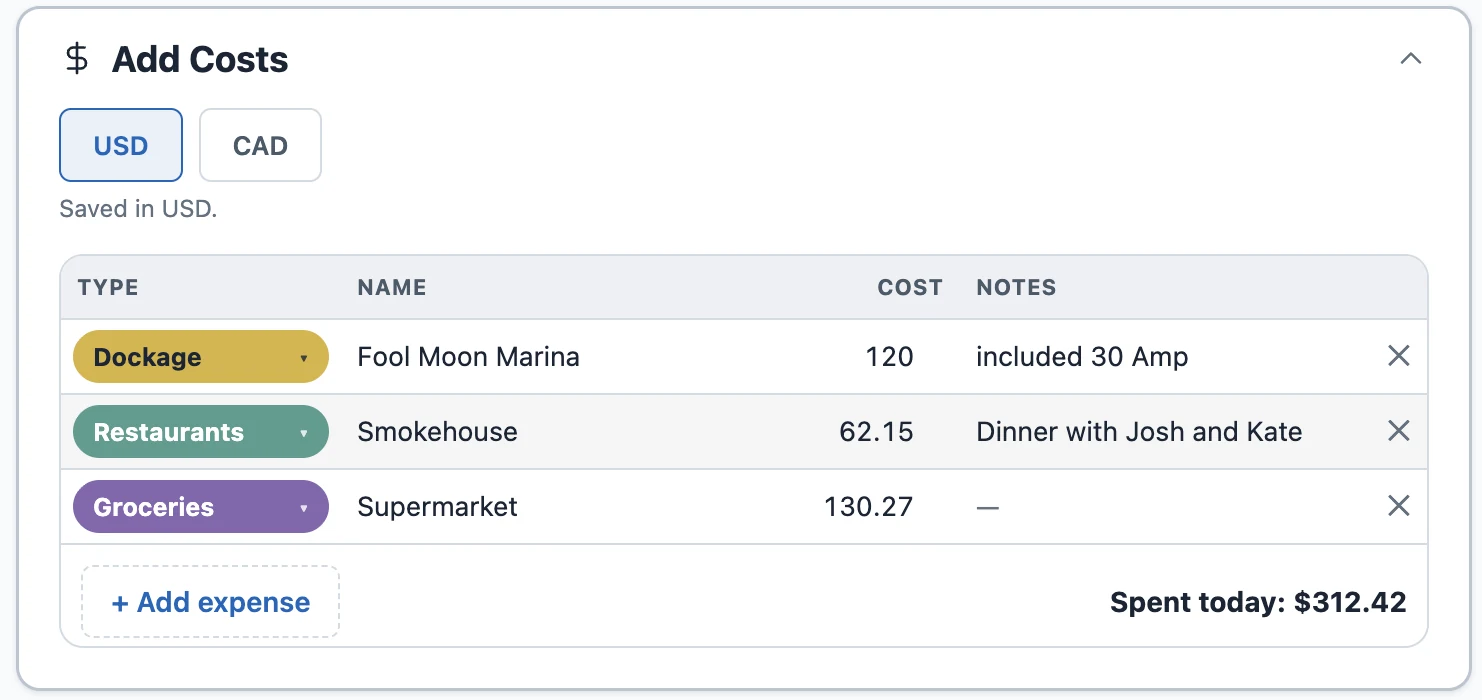
Each day used to give you a handful of fixed cost boxes. Now you log every expense as its own line — type, place, and amount — so groceries stay separate from restaurants and the fuel dock gets logged by the gallon or the litre.
A day's costs, itemized — type, place, amount, and a note.
Why we changed it
The old cost boxes were quick but blunt — "Food" lumped groceries, restaurants, and that $6 ice cream into one number, with nowhere to note the marina or what fuel really cost. So we turned the day's costs into a real ledger: as many lines as you want, each with a type, a name, and an amount.
Add a line for whatever you spent
Open a day, tap Add Costs, and add a line: pick a Type, name it in the "where / what" field, and enter the amount — then + Add expense for the next. Add your own types if the defaults don't fit, and an empty day suggests the types you've used most on this trip.
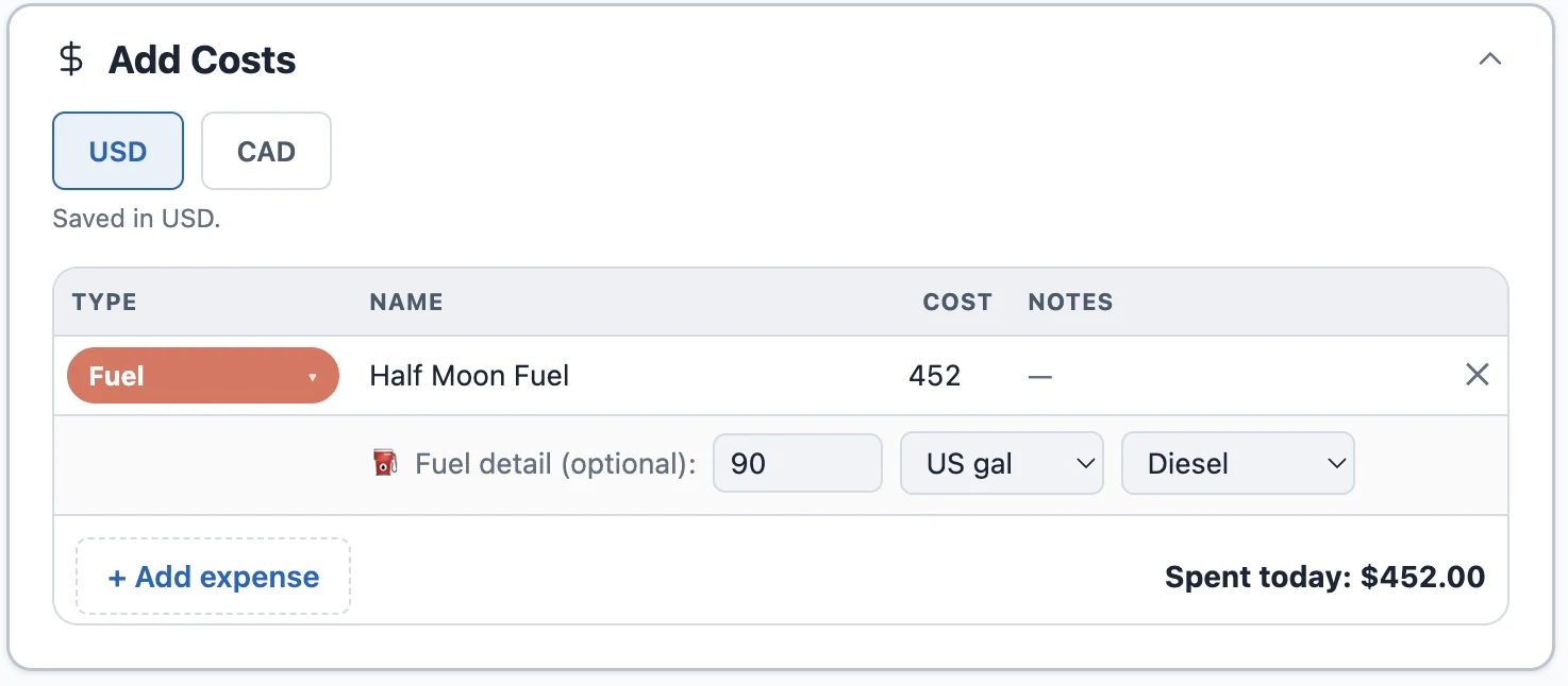
Buy fuel by the gallon or the litre
Log the receipt total, then — if you like — the gallons or litres and the fuel type.
Fuel gets a little extra: log what the fill cost, then — optionally — the quantity, with a US gal / litres switch on the row. Litres in Ontario, gallons in Florida; it still totals cleanly and works out your price per gallon.
Spend in Canada, see it in your own currency
Crossing into Canada or the Bahamas? Tap CAD, enter the amount off the receipt, and Loop Captain saves it in your home currency — so every total stays in the money you think in.
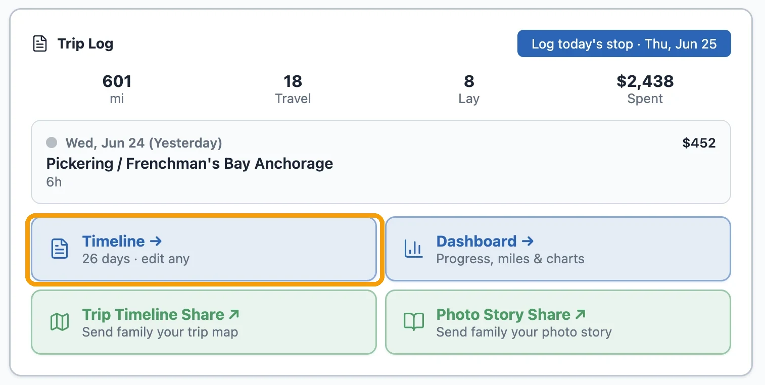
Find it under My Trip → Timeline
My Trip → Timeline opens your day-by-day log.
Your costs live with your days. Tap My Trip, then the Timeline card, to open the day-by-day list — add or edit any day's costs there.
Take the whole thing as a spreadsheet
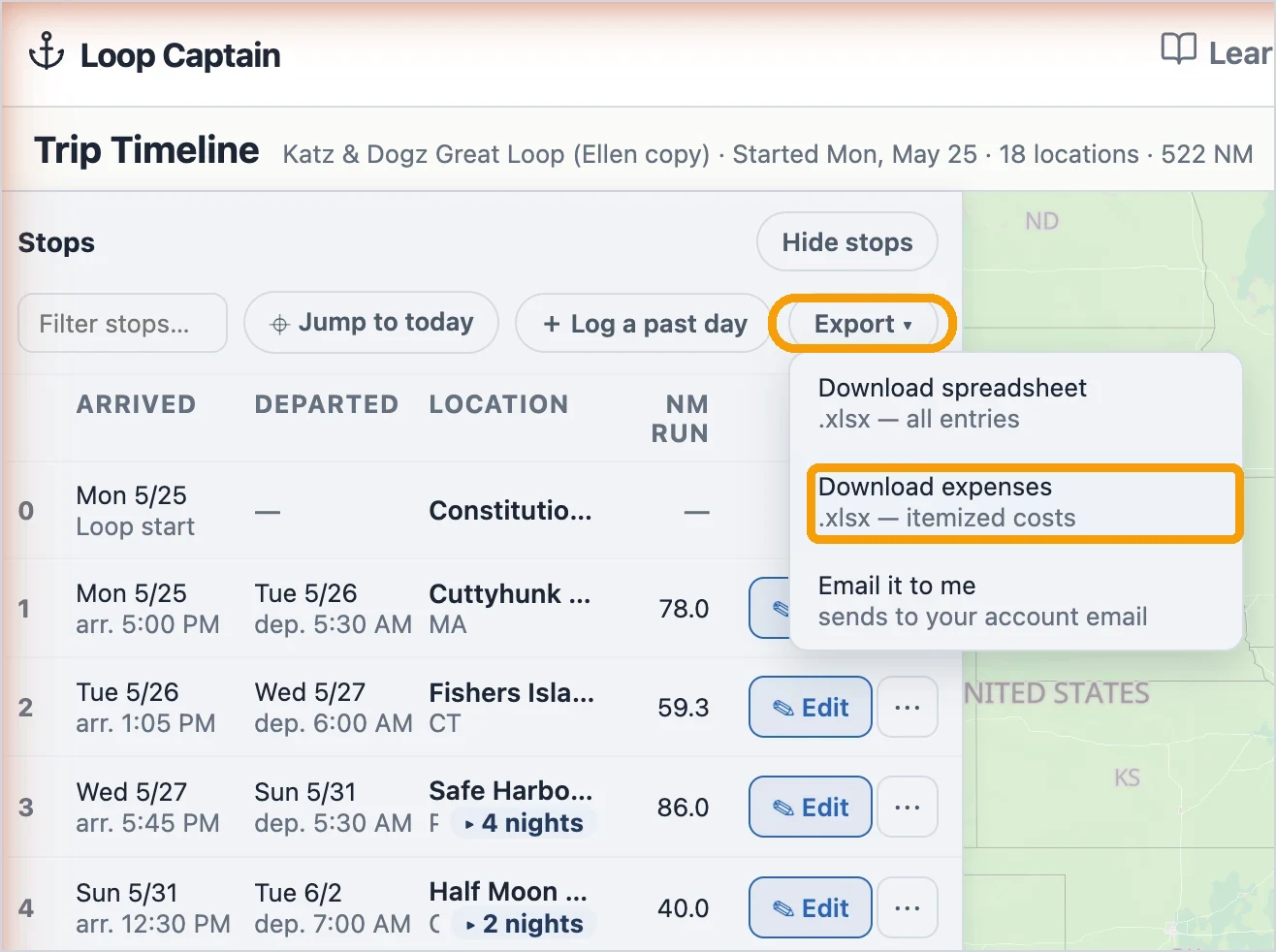
On the timeline, Export → Download expenses.
On the timeline, tap Export → Download expenses for the itemized ledger as an .xlsx (or Download spreadsheet for the day-by-day view). Both come in your home currency.
Plenty of Loopers don't run the standard line. Now you can build the route you'll actually travel: tap your way through each fork, add the side trips you want, and save the whole thing as one continuous loop. No waypoints, no drawing.
A whole loop, built one leg at a time.
Why we built it
About half of Loopers run the classic route start to finish. The other half don't — they hug the Canadian shore, take the Tenn-Tom instead of the lower Mississippi, run the Rideau to Ottawa, tack on the Saguenay. We kept adding canned route options to cover the popular variations, and it was never going to keep up: people choose paths, not menu items.
So we built a route builder that lets you assemble your own path from the same waterways and junctions the standard routes are made of — and keeps it one continuous, valid loop the entire time.
Start with one tap
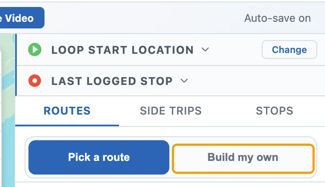
Plan → Routes → Build my own.
Open the Plan tab, go to Routes, and flip the switch at the top from Pick a route to Build my own. The map takes over and a panel opens at your home port — a blank canvas with your start on the map and nothing else committed yet.
Walk your loop, leg by leg
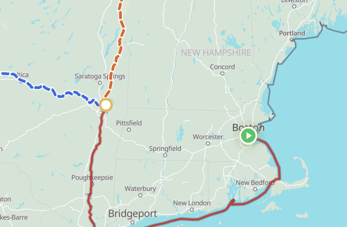
At a fork, every way onward is its own highlighted leg — with its distance.
From your start, the legs you can take next are highlighted right on the water. Tap one to add it; the panel keeps a running tally of your legs and miles. When more than one way leads onward, you're at a fork — each option is its own colored line with its distance, and you tap the one you want. Oswego or the Welland Canal. The inside passage or the open lake.
Made a wrong turn? Back a step peels off the last leg; Start over clears the build. Nothing you tap is committed until you save.
Add the side trips you want
Side trips branch off and come back. Tap the yellow dot to add one.
Side trips — the Saguenay Fjord, the Rideau to Ottawa, Lake Champlain, the Keys, the Potomac up to D.C. — branch off your route and come back. Where one is offered, a yellow dot sits at the end of a short branch. Tap it and the side trip weaves in as an out-and-back.
Don't want to run all the way to the end? Set a turnaround partway — or drag the yellow dot along the branch — and the trip stops where you do.
Always one whole loop — and yours to change
When the loop closes back at your start, Save it.
Keep walking until your route comes all the way around to your home port. The moment it closes, a Save route button appears — you can only save a loop that actually closes, so you're never left with a broken path. Save it and every map, briefing, and timeline follows the route you built, side trips and all.
A saved route isn't locked away. Open it and tap Edit route to walk it again, and — before your trip starts — you can switch back to a standard route anytime.
There's a step-by-step guide
We also wrote a full how-to with screenshots of every step. Find it in Learn → How-Tos, or go straight to “How to Build a Custom Route in Loop Captain.”
The page your family and dock mates open got a full redesign, your trip maps gained a Map key, and the morning briefing stopped saying things that aren't true.
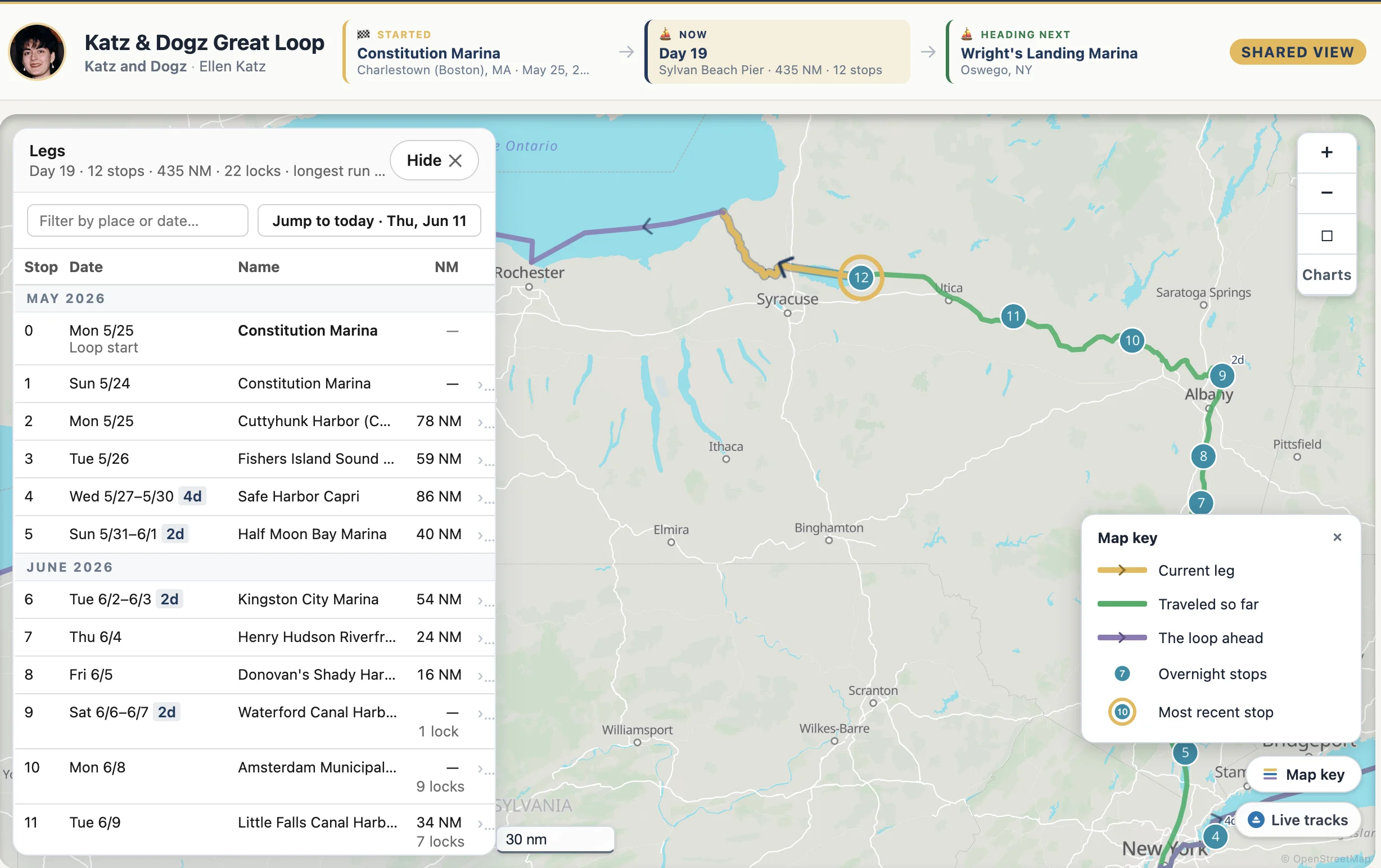
The shared view: stop 0, month dividers, trip stats — and a Map key that names every line.
The shared Trip Map Timeline, redesigned
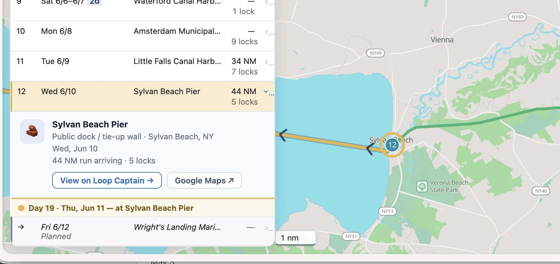
Click any stop: the map flies there and the card opens — stay dates, the run in, and links out.
Share your trip and visitors now get:
A milestone band: where you started, what day you're on — and, when you've shared one, where you're heading next.
A stops table that opens with your Loop start as stop 0, weekday dates on every row, and month dividers as the trip grows.
A gold marker line — "Day 32 · Thu, Jun 11 — at Sylvan Beach Pier" — showing exactly where you are in the list.
Clickable rows: the map flies to the stop and a card opens with the facility's type, town, your stay dates, the miles run — plus links to the facility on Loop Captain and on Google Maps.
The planned next stop as its own row, expandable like the rest.
Trip stats in the header: day count, stops, total miles, longest run.
A framed map with your traveled route in green — same color as your own view.
Every map explains itself
A "Map key" button now sits on the shared view, the Trip Map, and the Timeline. Tap it and every line and pin on that map is named, drawn in its actual style — today's leg, the water behind you, the route ahead, your stops.
The route ahead changed from blue to purple — it can no longer be confused with the water you've traveled.
The distance scale is now a readable chip on every map instead of a faint line.
Briefings that tell it straight
Several fixes to what the morning briefing says about bridges, locks, and itself:
Fixed bridges never "open" — the briefing now says so, gives the published clearance, and notes that actual clearance varies with water level.
Locks carry their real radio channels — channel 13 across the NYS canal system, with the exceptions noted.
Canal operating hours print once, not repeated for every lock on the leg.
The briefing card states exactly what it covers: "Sylvan Beach Pier → Wright's Landing Marina · generated Thu, Jun 11, 6:00 AM."
Arrive somewhere and the card knows: it offers to regenerate for the next leg instead of presenting the finished one as current.
Logging, with fewer ways to go wrong
Started your Loop before you found Loop Captain? Set your start, then backfill day by day — there's a How-To guide, and the first logged day now works on every trip.
Logging a missed day suggests the right previous stop for that date, not wherever the boat is now.
Lay days attach to the stop you picked, not the date's other arrival.
Days entered out of order wire themselves correctly.
When a save can't go through, you get the reason in plain English — "The arrival time must be after the departure time for that day's run" — not an error code.
Also in this release
Trip Map Timeline and Photo Story share buttons now sit right on your Trip Log card.
The Plan & briefing card leads with "Read briefing" when your briefing is ready and current.
A new "Loop Captain How-Tos" section opens the Learn page — step-by-step guides to the app itself.
No body text smaller than 13px on My Trip, the briefing, or the timelines.
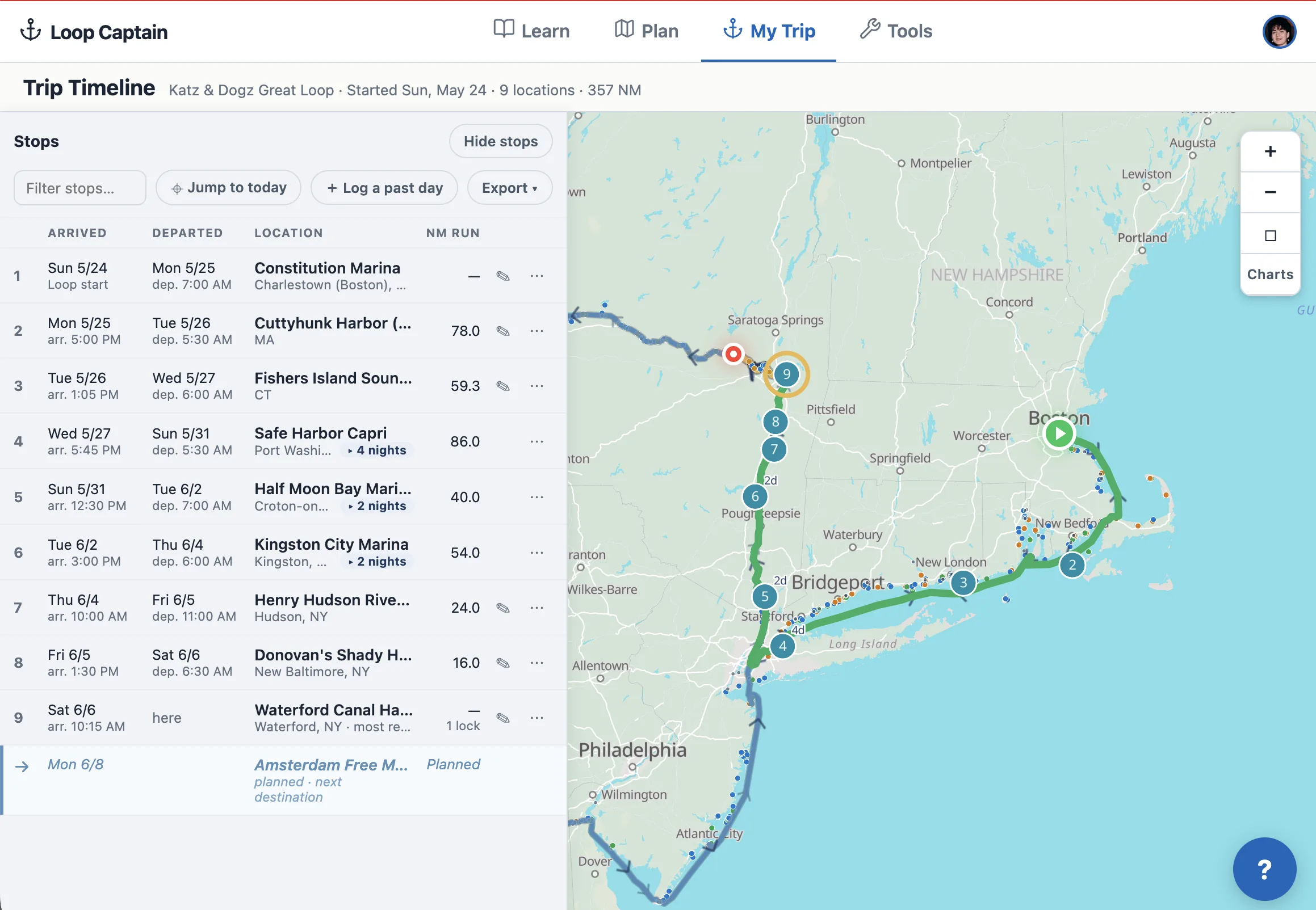
Your trip log now reads like a captain's table: every stop on one line — when you arrived, when you left, how far you ran — with any day one tap from fixing. And on every map, the water you've already crossed is painted green, right up to today's arrival.
Every stop on one line, and the miles you've made in green.
A Timeline built around your stops
Open Timeline from your Trip Log card and you get a clean table of the journey so far: one row per stop, numbered in order, with Arrived and Departed dates (each leading with the weekday — "Thu 6/4"), times when you logged them, and the miles you ran to get there. Stay somewhere a few nights? The row says "2 nights" and expands to show each day — travel days, lay days, today marked (Today).
Anchored on a spot without a name? It now reads like a place: coordinates plus the nearest town — "43.229°N, 76.299°W · Phoenix, NY."
Click any row and the map glides to that stop, marking it with a pulsing blue ring — blue is always your selection, gold is always your most recent stop, so the two can never be confused.
Fix any day, fill any gap
Every row has a menu: edit the day, add a lay day, add a stop on a date, or delete a day. Skipped a week of logging? The Timeline shows the gap — "5 unlogged days" — with an Add button right there, and a "Log a past day" button up top for anything else. Exports (print, spreadsheet, email) moved here too, so the record of your trip and the tools to polish it live on the same page.
The water behind you is green now
On the Timeline map and the My Trip mini map, your completed route draws in green — distinct from the gold of today's leg and the blue of the route ahead. The moment you log tonight's arrival, the day's run turns green with it. That green line is your wake.
Maps and forms that say what they mean
The My Trip mini map now always explains itself in a caption below the map: "Showing the leg for Sat, Jun 6 (Today)" before you arrive, and once today's arrival is logged, "Showing your NEXT leg" — with the reason. No more guessing what the line on the map represents.
The log's time fields got the same honesty: instead of bare "Departed" and "Arrived" labels, they name the places — "Departed · Kingston City Marina" and "Arrived · Henry Hudson Riverfront Park" — so it's clear the departure belongs to the stop you left, not the one you reached.
Saves you can trust — thank you, Ellen
Two bugs found by Ellen aboard Katz & Dogz are fixed. Editing a travel day's location used to report success while quietly keeping the old spot — location edits now save everywhere. And when any part of an edit can't be saved, the app now says exactly what failed instead of showing "Entry updated" regardless.
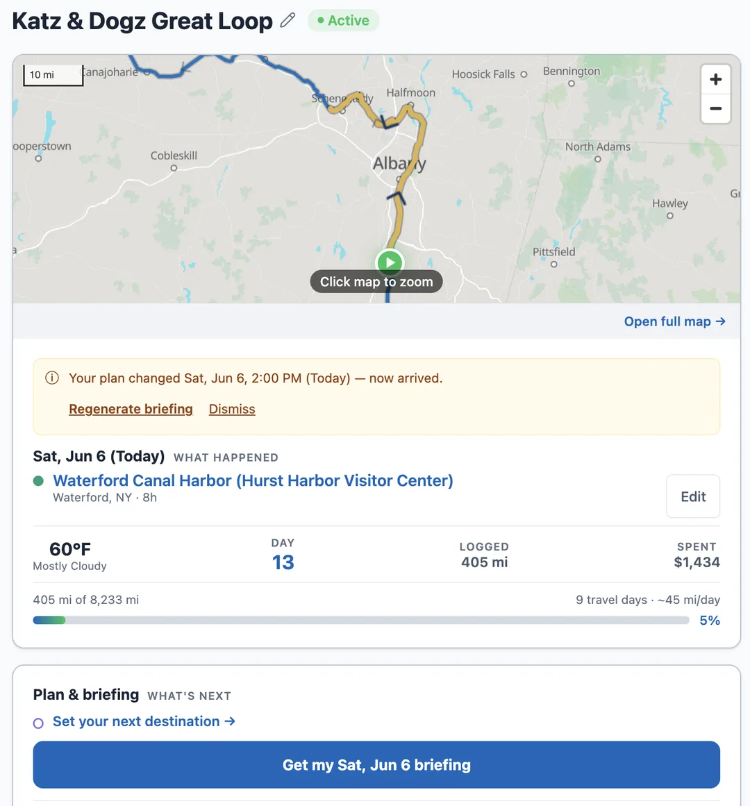
Your trip page is now three clean cards — where you are, what's next, and your log — with your plan and its morning briefing finally living together. One line tells you whether your briefing covers the leg you're on; one button refreshes it. And every date is written out in full, so there's never a doubt which day we mean.
Where you are and what's next — one clean page, every date written out in full.
Three cards instead of five
My Trip used to be a long stack of overlapping panels — the map, the day's status, your plan, a separate briefing reader, and the log all competing for attention. It's now three clean cards. The first shows where you are: the route map with your current position, weather, and trip progress in one place. The second is your plan and its briefing, together. The third is your trip log.
Each fact appears once, where you'd look for it.
Your plan and its briefing, on one card
Setting where you're heading and reading the briefing that routes you there used to live in different places. Now the Plan & briefing card holds both, and a single line tells you exactly where you stand: a green "Briefing ready — covers this leg" when you're set, or a clear "Out of date — generated before you set this destination" with a one-tap regenerate when your plan has moved on.
The plan also keeps itself current. Log an arrival and it becomes your new starting point — yesterday's destination doesn't linger. Take a lay day and the card says plainly that your departure slid a day. And your morning briefing email now names the leg right in the subject line — where you're starting, where you're headed, and the date.
Dates and places, written out in full
Every date in the app and in your briefings now leads with the actual day — "Sat, Jun 6 (Today)" — never a bare "today" or "tomorrow." The log asks about a specific night: "Where are you stopping for the night of Fri, Jun 5?" When plans shift day to day, you always know exactly which day a label means.
Coordinates got the same treatment: anywhere you'd see raw latitude and longitude, the nearest town now appears beside it — "43.229°N, 76.299°W · Phoenix, NY" — so a pinned anchorage reads like a place, not a number.
Your Timeline and Dashboard, one tap away
The Trip Log card now has two dedicated buttons. Timeline opens your day-by-day log, where you can step into any day and edit it. Dashboard opens your trip's story in numbers — loop progress, miles, milestones, spending, and charts. Both used to hide behind one faint link; now each has its own button.
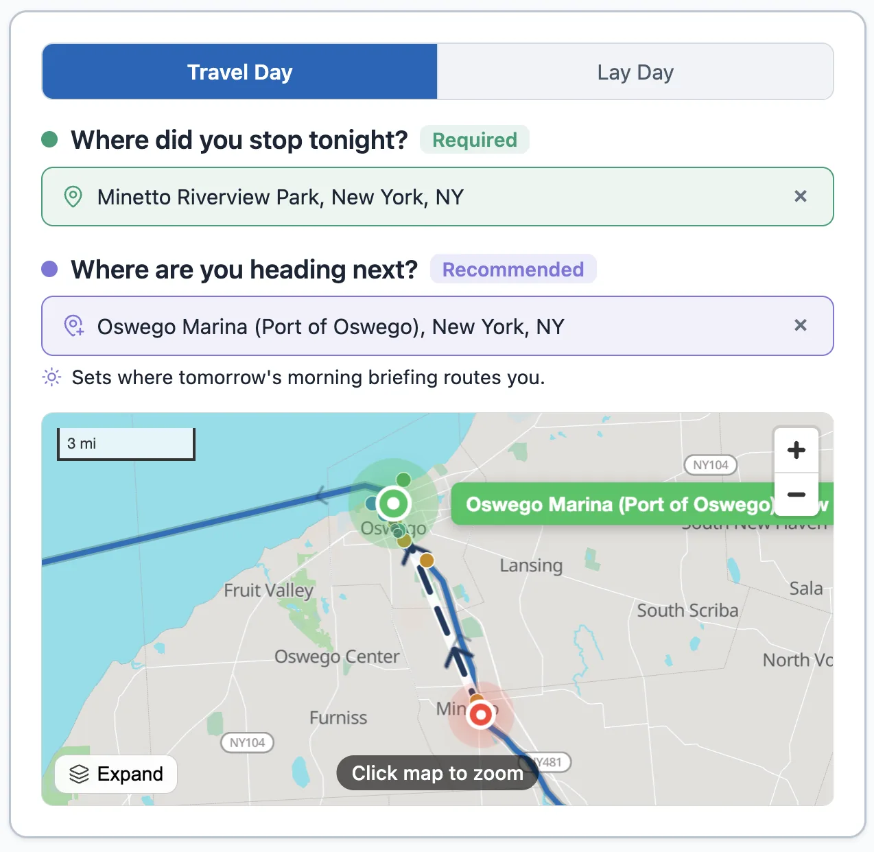
Setting tonight's stop and tomorrow's destination now happens right inside your log — no more bouncing out to the planner and back. My Trip is rebuilt around the leg you're actually on, you can log or fix any day, and your morning briefing refreshes the moment your plan changes.
Set tonight's stop and tomorrow's destination right in the log — no trip out to the planner.
Log your stop without leaving the page
When you log a travel day, "Where did you stop tonight?" and "Where are you heading next?" are now answered right there in the log. No round-trip out to the planner and back — the page you start on is the page you finish on.
Three ways to set a spot, whichever is easiest in the moment:
Search a marina, anchorage, or town and pick it from the list.
Tap the map to drop a pin exactly where you tied up.
Use my location — one tap grabs your current GPS position for tonight's stop.
A clearer My Trip page
My Trip now leads with the leg you're actually on: your last stop and your next destination, side by side and always in view. If you haven't set where you're heading next, there's a gentle nudge to do it — because that's what your briefing plans around.
We also untangled the status. Before, the page could read "arrived" and "lay day" and "out of date" all at once. Now there's one honest answer to "where am I, what's my next leg, and is my briefing current?" — and an out-of-date briefing is clearly flagged as something to refresh, not a competing status.
Everyday things sit up top; trip setup, position history, and your send-off are tucked into tidy sections you can open when you need them.
Log — or fix — any day
The log now shows the date up front, with back and forward arrows. Missed logging a stop a couple of days ago? Step back and add it. Need to fix something on an earlier day? Step to it and edit. You can move through your whole trip a day at a time — and you can't accidentally log a day in the future.
A briefing that keeps up with your plan
Your morning briefing now keys off your actual plan. Change where you stopped or where you're heading next, and your next briefing is built around the new details — and you no longer have to wait out a fixed time window to get an updated one. When nothing has changed, the app reuses your existing briefing instead of regenerating an identical one. And if your plan changes during the day, My Trip flags that your briefing is out of date and gives you a one-tap regenerate, so you can refresh it on the spot.
We also tightened up accuracy: briefings stick to the real geography of your route, don't invent details that aren't in your logs, and handle bridge and weather-alert wording more carefully — so what you read in the morning matches what you find on the water.
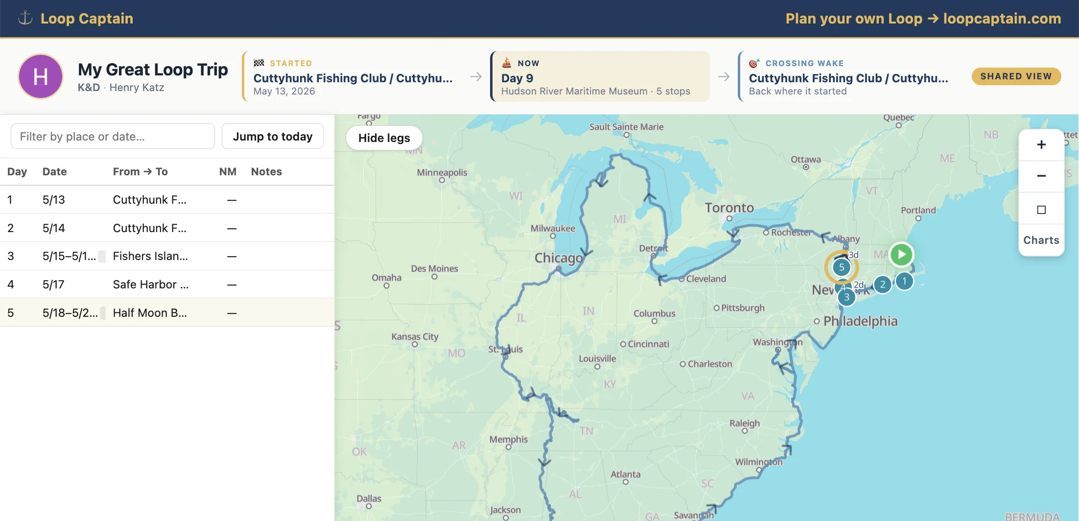
The Trip Map Dashboard now lays out your entire Loop on one screen — every stop you've logged, today's leg, and the route still ahead. And from My Trip you can mint a public link that opens a clean, read-only version of that view for fellow Loopers, family, or anyone you want to follow along. No sign-in required on their end. You stay in control of what's visible and can rotate or revoke the link whenever you want.
The new shareable Trip Map Dashboard — your whole journey on one screen.
A public link to your dashboard
From My Trip, hit Create share link in the Share your trip card. You get a public `/dashboard/<token>` URL you can drop in a text, email, or AGLCA forum post. Anyone with the link opens a read-only view of your trip — no Loop Captain account needed.
It's a read-only mirror, not a live edit surface. Viewers see the map, the milestone band, and the day-by-day stop list, but there are no edit buttons, no log forms, and no buried trip settings — just your journey. You stay in control of what's actually written.
You choose what fellow Loopers see
Three visibility levels, switchable at any time from the same Share card:
Everything — past stops, today's leg, and the planned future arc.
Past + today — past stops and today's leg, but the future path is hidden (useful if you'd rather not telegraph the next several weeks of cruising plans).
Past only — just the stops you've already logged.
Revoke or rotate when you're ready
Sharing isn't forever. From the same card you can Rotate the URL (old link stops working immediately, new one takes over) or Revoke it entirely. Both prompt you to confirm so you can't trigger them by accident.
What viewers actually see — the dashboard itself
The dashboard packs your whole Loop onto one screen with three visual layers, each telling a different part of your story:
Past stops as numbered teal pearls, with a gold halo on your most recent one — eyes land on "where they are right now" instantly.
Today's leg as a bold gold line with direction chevrons.
The rest of the enabled Loop as a sky-blue line tracing the path still waiting.
Milestone band — Started, Now, Crossing Wake
Above the map, three cards anchor the story for anyone opening your link cold: where your Loop began, where you are right now (with day count and stop count), and the point where you'll cross your own wake to complete the Loop. Once your trip closes the wake, the third card lights up to mark the moment.
Day-by-day panel that talks to the map
Both you and your viewers get a side panel listing every stop in order — day number, date, from-to facilities, nautical miles (with a locks badge underneath when relevant), and notes — plus a quick filter and a Jump to today button. Click any row and the map pans to that pearl with a read-only details card; click any pearl on the map and the matching row scrolls into view. The URL bundles the selected day too, so you can deep-link friends to a specific stop on your trip.
Your daily log, your trip page, and the morning briefing now each show a small map of today's route — from where you started to where you're heading, with distance and a rough time estimate. Tap to expand to the full map; tap Edit on either pin to fix the underlying log entry.
Today's plan, inline on the daily log form.
A mini-map on the surfaces you already use
Three places now show today's route inline:
The daily log form (Log Today / Edit Today) — below the chip where you set tomorrow's destination, both on desktop and on mobile
My Trip — under the day-counter on the v2 mobile page, and on the v1 desktop page too
The morning briefing email — a "View today's route" button at the top that drops you straight onto the full map for that day
Tap to expand for the full picture
Tap any inline map and on mobile it opens as a fullscreen sheet; on desktop, "Open full map →" takes you to the dedicated route page. When you arrive there, a clear "← Back to log entry" / "Back to My Trip" button is waiting in the header so you don't lose your place.
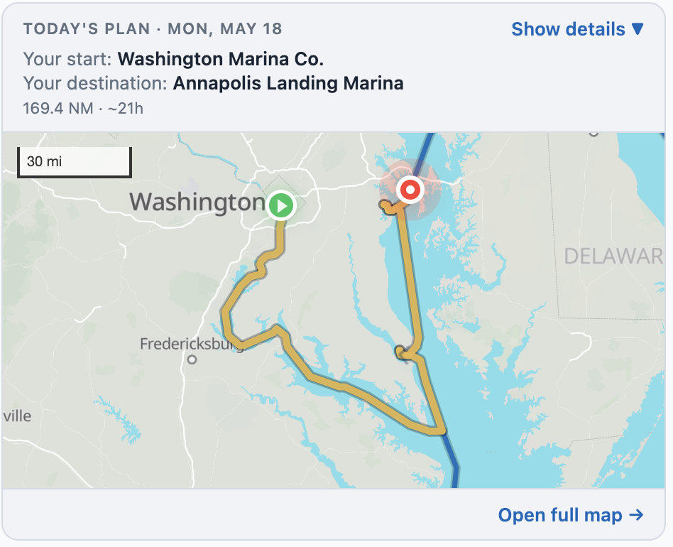
Today's plan, labeled so you can tell what you're looking at
The inline map opens with a short header so there's no ambiguity:
TODAY'S PLAN · MON, MAY 18 — so you always know which day it's framing
Your start: the marina or anchorage where you tied up last night
Your destination: where you're heading next (or a friendly nudge to set one)
Distance, rough travel time, and bridge count on a single line
Show details — see who said what, and when
Tap "Show details ▼" and a card opens with the provenance: a small green pin next to your starting facility and a small red pin next to your destination, each with the "Logged via Log Today on Thu, May 14, 5:00 pm" stamp and an Edit link so you can jump straight to the entry that set it. No guessing how the route got built.
Pick a destination and the map shows it right away
Before today, after you picked tomorrow's destination from the picker, the map didn't update until you hit Save on the log form. That created a moment of "did it take?" Now the destination saves the moment you return from the picker — the embed shows the new route immediately, and the Save button is reserved for any free-form notes you've added.
Distant destinations render the whole way
There used to be a hard 150-mile ceiling on how far the route preview would draw — so if you committed to a 180-mile run (some Loopers do, especially in open water), the embed showed only the first 150 miles and the destination floated alone. Now, whenever a destination is set, the route draws all the way to it. The ceiling stays for the "where might you end up tomorrow?" prediction when you haven't committed yet, but it never crops a destination you've actually chosen.
Today's leg, before the trip officially starts
If your trip start date is still in the future and you peek at today's route, the embed now opens with a small caption — "Planning your first day from trip start anchor" — so you know the line you're looking at is your planned Day 1, not an actual logged leg. The caption disappears the morning your trip begins.
Set tomorrow's destination when you log tonight's stop, and the morning briefing plans toward it — distance, marinas and anchorages along the way, weather at your destination, a heads-up if it looks like you're heading the wrong way.
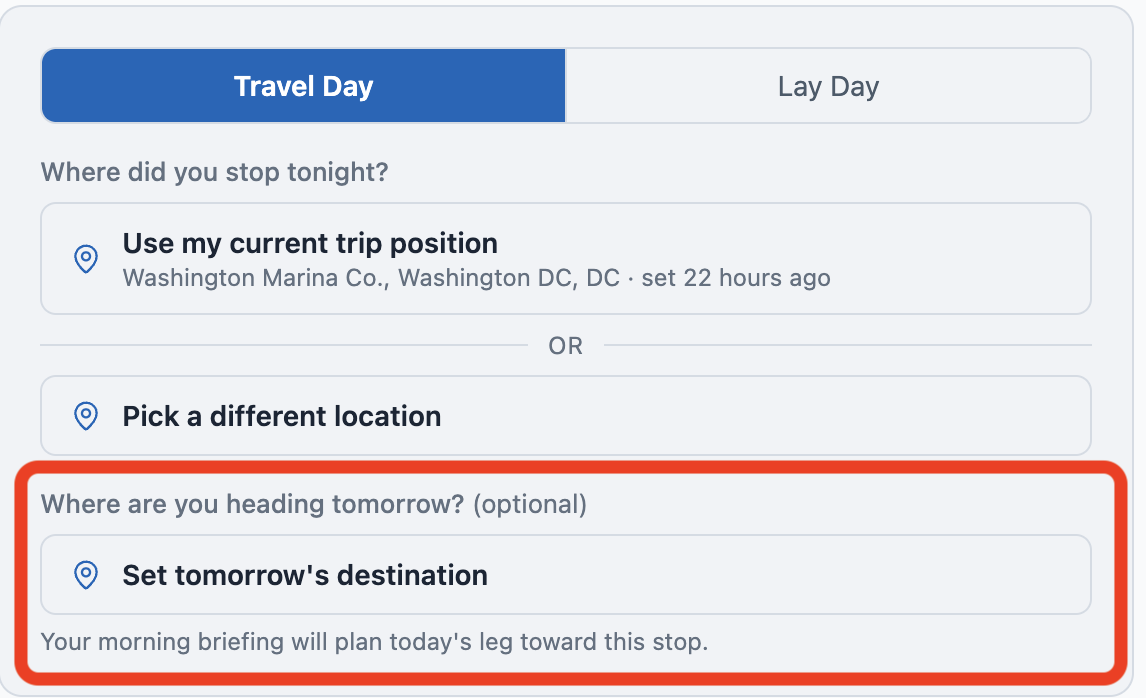
The new section on the daily log form — set tomorrow's destination when you log tonight's stop.
Set tomorrow's destination from your daily log
On the daily log form (Log Today or Edit Today), below where you log tonight's stop, there's a new section: "Where are you heading tomorrow? (optional)". Tap "Set tomorrow's destination", search by marina or anchorage name, or switch to the Map tab and tap your spot. Save the log.
The next morning's briefing reads your destination and plans the day toward it — leg distance, stops along the way, weather at the destination, locks and bridges you'll pass. Before this, the briefing guessed where you'd end up based on the canonical route; now it knows.
Today's Route table starts where you're starting
The "Today's Route" table at the bottom of the briefing now opens with your starting location, marked 📍 Start of today's leg. Stops are listed in the order you'll pass them, ending with 🏁 your destination if you set one. No more confusing rows at "0.0 NM" — the table now matches what your day actually looks like.
Heads-up if your destination is behind you
Pick a destination that's behind your direction of travel — say you're heading north up the ICW and you tap a marina back south — and the picker warns you: "This appears to be behind you. Save anyway?" Sometimes that's intentional (you're going back to pick something up). The warning is non-blocking; you can save anyway.
Generate Now does the right thing
If you've already logged today's stop and tap "Generate Now" on My Trip, you get tomorrow's briefing — the one you haven't seen yet — instead of re-running today's. The preview line and modal header now show both dates: which day the briefing is for, and how long ago it was generated.
My Trip shows what's set
The Tonight card on My Trip gets a "→ Heading to X tomorrow" chip when you've set a destination. The "Today's briefing" card below echoes it — either "Tomorrow's destination: <name>" or "Tomorrow's destination is not set" with a prompt to set one if you want destination-aware planning.
The clockwise / counter-clockwise toggle on the planner now saves to your trip and follows you everywhere — the route arrows, the planning tools, the briefing. And anchorages with rough coordinates are out of the map; the ones you see are the ones you can navigate to.
Set your direction, and the whole product follows
Open the planner, tap the direction button on the right edge of the map, and it flips between ↻ Clockwise and ↺ Counter-clockwise. The choice saves to your trip immediately.
After you set it, you'll see:
The arrows along the route on the planner map reverse to point in your travel direction
The list of stops in the planner reorders into the sequence you'll actually pass them
The animated route preview plays the loop your way
The five planning tools — Bridge Clearance, Fuel Calculator, Passage Planner, Seasonal Planner, Trip Budget — all order their results in your travel direction
Tomorrow morning's briefing narrates your day's leg in the right direction
The Direction chip on My Trip
On My Trip and on each trip's detail page you'll see a new chip — "Direction: ↻ Clockwise · Change" — that confirms the setting at a glance. The Change link takes you back to the planner to flip it.
Trustworthier anchorages on the map
Anchorages have been hidden by default on the planner map for a while. The reason was honest: a lot of anchorage entries in the database came in with coordinates accurate to about a kilometer — fine for "this cove is a good anchorage," not fine for "drop the hook here." Rather than show options we couldn't fully trust, the planner just hid the type.
We've now cleaned that up. Anchorages with point-precise coordinates are shown by default on the planner map; the ones we can't verify are filtered out of the planner, the fuel-gap calculator, and the daily briefing. As we get verified coordinates for the rest, they'll come back online.
The daily briefing email got smarter about the marine forecast, opens with a "behind today's plan" panel showing what built it, and rolls "Upcoming Stops" + "Navigation Notes" into one ordered table.
Marine forecasts and warnings now follow your whole day
The old briefings checked wind at your starting point and missed alerts that NWS issues by water zone — not by land county. So if you started in a sheltered harbor but your day's route crossed open water with an active Small Craft Advisory, the briefing didn't see it.
That's fixed. The briefings now sample your day's route at five points, look up every marine zone you'd cross, and pull warnings from each. If any zone has an active SCA, Gale, Storm, Hurricane, or Special Marine warning, the briefing recommends a layover — full stop. No more cheerful "great day to move" on a four-foot-chop day.
"Behind today's plan" — see exactly what went into the briefing
Every briefing now opens with a panel showing what we used to build it:
Your boat profile (LOA, draft, air draft, cruising speed × daily hours)
Today's leg distance and the cardinal direction you're heading
How fresh your last position update is
The routes you've enabled
The weather sources we pulled
The facilities along the leg
One clean "Today's Route" table
The "Upcoming Stops" and "Navigation Notes" sections are now a single ordered table:
Type icons for bridges, fuel docks, locks, anchorages, marinas, dock walls
Each stop with its distance from your starting point and type-specific notes
Warnings (low clearances, depth limits) shown in red and bold so they don't get lost in the prose
Direction-aware briefings
If you're cruising the Loop and your position sits on a side trip you haven't entered yet, the old briefing could point you the wrong way — sending you further up a dead-end river instead of forward along your actual route. The briefing now honors the same direction logic the planner uses, so what it tells you matches what your trip actually does.
Anchorages with rough coordinates are now filtered out
About a third of the anchorages in our database came in with low-precision coordinates — accurate to about a kilometer, which is fine for "this cove is a good anchorage" but not fine for "drop the hook here." Those are now excluded from briefing recommendations. We'd rather show you fewer options than send you toward shallow water or off the navigable channel. The well-sourced anchorages are unaffected.
Preview briefings for upcoming trips
If your trip start date is still in the future, your briefings now correctly say "Preview · trip starts in N days" instead of pretending you're already underway. The narrative drops "cast off this morning" language so it doesn't read as an active-day plan.
Incomplete boat profiles get a heads-up
If your boat profile is missing a key field (like cruising speed), the briefing now tells you straight up — "Boat profile: incomplete, defaulting to 5-hour days" — instead of producing a confusing recommendation with no explanation. Open Settings → Boat to fill in the missing pieces.
Transparency at the top of every email
Every briefing now leads with a short note explaining why you're receiving it and where to turn it off (Settings → Notifications). No surprises.
Side trips like Bahamas, Nashville, Knoxville, and St. Johns are now partial. Pick a turnaround point along the spur and the trip plan, cinematic, stats, and briefings all honor it.
Why partial side trips matter
A spur side trip — Bahamas out of Stuart, Nashville up the Cumberland, Knoxville up the Tennessee, St. Johns up from Jacksonville, Boston Harbor, the Champlain Canal, the Potomac — used to be all-or-nothing. Either you went the full out-and-back, or you skipped the spur entirely.
That doesn't match how cruisers actually move. You might run halfway up the St. Johns and turn around, or take Nashville to a specific marina and head back. So we built partial side trips: pick a turnaround point along the spur and everything downstream of that point gets honored — distance, days, fuel, briefings, the cinematic, the U-turn marker on the map.
Setting a turnaround
When a spur side trip is selected, a Turnaround chip appears on it. Tap it and a modal opens with two ways to pick where you turn around:
Pick on the map — the planner auto-zooms to the spur so you can tap exactly where you want to turn around
Pick a facility — search a marina or anchorage along the spur and the turnaround snaps to it
Everything updates
Once a turnaround is set, the trip statistics reflect the partial distance and the partial days. The fuel calculator and trip budget adjust. The cinematic plays out to your turnaround point and back. The map shows a U-turn marker at the turnaround. Briefings reaching the turnaround day get a heads-up.
Reset whenever
Change your mind? The turnaround chip has a Reset button. Clear it and the side trip goes back to the full out-and-back.
Which side trips support this
All twelve spur-shaped side trips on the Great Loop: Bahamas, Nashville, Knoxville, St. Johns, Boston Harbor, Champlain Canal, Potomac / D.C., Miami ICW South, plus the four side trips on the Down East Loop (Penobscot Bay, Bras d'Or Lake, Cape Breton, St. Pierre & Miquelon). Loop sections themselves — Lake Michigan, Tenn-Tom vs Mississippi, etc. — aren't affected; they're still all-or-nothing.
The biggest data ingestion pass since launch — 47 new facilities, 26 updates, and three cleanups. Net 44 new marinas, anchorages, locks, and dock walls along the canonical route.
What's new on the map
We added 47 new facilities and updated 26 existing ones across the Loop. Coverage in this pass leaned heavily on three regions:
Trent-Severn Waterway — many new lock approach walls (free tie-ups at each lock chamber)
Tenn-Tom Waterway — Lower Cook's Bend, Bashi Creek, Big Briar Creek, Big Blue Island, and more anchorages
Mississippi River — Paducah municipal dock and other municipal walls
Plus a scattering of additions on the Cumberland, the ICW Atlantic, and the Dismal Swamp
How we vet new facilities
Every new facility gets researched against a source hierarchy — official charts and operator information first (NOAA, Parks Canada, USACE), then operator and structured guides (Waterway Guide, marina websites), then cruiser reports (ActiveCaptain, forums). Every cited field carries its source. We won't post depth, clearance, or fuel availability unless it traces to a source we trust.
Anchorage coordinates
For anchorages specifically we now insist on tight coordinates — cruiser-GPS-grade where available, with a satellite-view sanity check before publishing. An anchorage that puts your boat in shallow water or off the channel is worse than no anchorage; we'd rather not list it than list it wrong.
Find them
Pull up the planner and zoom into the regions above. Anchorages are hidden by default — tap the Legend filter to reveal them. Search by facility name in the Stops tab will surface the new entries.
Two big things this morning: the Down East Loop is now a selectable loop variant — a 2,400 NM full Maritimes circumnavigation. And we added a seventh facility type, Boat Ramp, for public ramps and trailer launches.
Down East Loop — the route
The Down East Loop is the Loop's bigger sibling: roughly 2,400 NM circumnavigating the Maritimes. You head up the Hudson, through the Champlain Canal into Lake Champlain, north up the Richelieu River to the St. Lawrence, east through Quebec and Nova Scotia, down through Cape Breton and back along the Atlantic coast to home.
18 spine segments plus four side trips — Penobscot Bay, Bras d'Or Lake, Cape Breton's Cabot Trail, and St. Pierre & Miquelon — each with verified polylines.
Switch loops without losing your trip
Use the Loop Type chip at the top of your trip details to preview the Down East Loop. Preview mode is ephemeral — no changes are saved until you click "Make Down East Loop my trip" and confirm. While you're previewing, your current Great Loop trip stays intact.
The four side trips
Each one is a meaningful detour with its own character:
Penobscot Bay (Maine) — Castine, Camden, Rockland
Bras d'Or Lake (Cape Breton) — a saltwater inland sea
Cape Breton's Cabot Trail — the eastern shore of Cape Breton
St. Pierre & Miquelon — the French islands south of Newfoundland
Read the guide
We also published a full Down East Loop article in Learn covering the route, the seasons, the Canadian customs side, and what to expect. Pull up Learn → Routes & Waterways → Down East Loop.
Boat Ramp — a new facility type
Public boat ramps now have their own facility type, separate from Dock Walls. A ramp is a different thing — you trailer in, launch, and head out. Each ramp shows the fee structure (Free / Paid / Donation), number of lanes, parking capacity, whether there are restrooms or fish-cleaning stations, and the depth at the ramp.
Boat Ramps are hidden by default on the planner map for the same reason anchorages are — they'd clutter the view for most cruisers. Tap the Legend filter to reveal them.
Smaller stuff
We also fixed a doubling bug in the cruising-distance shown on the Fuel Calculator, Trip Budget, Bridge Clearance, and Seasonal Planner pages — they now match the planner's total correctly.
A pass on mobile-planner clutter — anchorages are off by default, the legend is now a button, the Trip Waypoints section collapses on mobile, and 407 imprecise anchorages were filtered out so a bad coordinate can't send you to shallow water.
Anchorages off by default on the planner
Anchorages used to be visible by default and cluttered the planner map, especially on mobile where every dot competes for tap accuracy. They're now hidden by default. Tap the Legend filter, check Anchorages, and they appear.
We did the same thing for Boat Ramps (the new facility type that shipped yesterday).
The Legend is behind a button now
On mobile the legend used to be a permanent floating panel covering roughly a quarter of the screen — especially painful on iPhones with the planner pulled up. It's now a button on the zoom bar that opens a panel mirroring the Charts panel pattern (transparent backdrop, tap outside or hit Esc to close).
While we were in there, we made the Charts button highlight blue when its panel is open, and made the two buttons mutex — opening one closes the other.
Trip Waypoints collapses on mobile
The Loop Start / Current Location section at the bottom of the planner sidebar was eating ~190 points of vertical space on mobile, pushing the Routes tab below the fold. It now collapses to a single tappable pill by default and expands when you tap it. After you set a waypoint, it auto-collapses to free the space again.
Low-precision anchorages filtered out
About a third of the anchorages in our database came in with rough coordinates — accurate to maybe a kilometer, which is fine for "this cove exists" but not fine for "drop the hook here." 407 such anchorages are now hidden from the planner's facility search, the Nearby query, and briefing recommendations.
We're working on fixing those coordinates over time. In the meantime, you'll see fewer anchorages — better to show fewer good ones than mix in 407 that could send a boat off the channel.
Loop Captain now supports more than one loop. The Triangle Loop — a ~692 NM circuit through the Erie Canal, Oswego, Lake Ontario, the St. Lawrence, Montreal, and home down Lake Champlain — is the first alternate.
What the Triangle Loop is
The Triangle Loop is the most popular variant on the Great Loop — about a third the distance, a tenth the lock count, and roughly three to four weeks instead of nine to twelve months. You head up the Hudson, west through the Erie Canal to Oswego, north into Lake Ontario, east through the Thousand Islands and down the St. Lawrence to Montreal, then south through the Richelieu River and Lake Champlain back to where you started.
It's a real first-cruise loop. Lighter on commitment, easier on the calendar, and a great way to learn how to handle locks and customs before tackling the full Loop.
The Loop Type chip
At the top of your trip details there's a new "Loop Type" chip. Tap it and you'll see a two-section menu: Your Trip (whatever you're currently on) at the top, Preview a Different Loop below.
Tap any preview option and the planner switches to that loop — routes, side trips, stats, the map polylines — without touching your saved trip. The chip turns amber and dashed to remind you you're previewing. A "← Back to my trip" link lets you exit back to your real trip.
Make it your trip
When you're sure, click "Make Triangle Loop my trip" and confirm. The switch is one explicit action — no autosave on preview, no surprise commits. Your route options, side trip selections, and trip log all stay; just the underlying loop changes.
Side trips on the Triangle Loop
The Triangle Loop has one opt-in side trip: the Lower Hudson — from NYC north to Waterford if you want to start (or end) your Triangle loop in the harbor. Otherwise the Triangle starts at Waterford and you take the canal west from there.
Read the guide
There's a full Triangle Loop article in Learn now — covers the route segment-by-segment, the seasonal timing window, lock counts, and the Canadian customs side. Look for it under Learn → Routes & Waterways.
A big rebuild of how the route planner decides what to show and what to enable. Side-trip selections work the way you'd expect now. The cinematic starts from your actual start point. And the iPhone zoom bar fits in landscape.
Side trips behave correctly now
If you selected the Florida Keys + the Miami side trip, the trip used to route through Miami twice — once on the way down the spine, once on the spur — producing a visible circle-back on the map and a wrong distance total. Fixed. The Miami spur is now a side trip off the Okeechobee waterway, where it always belonged geographically.
More broadly: side-trip availability, mutual exclusivity between routes, and the cascade rules for what each loop offers all moved from front-end code to a backend route-planner service. The user-visible result is that route selections behave more predictably — you can't accidentally pick mutually-exclusive routes, you can't accidentally end up with an empty mutex group, and side trips that aren't reachable from your selected spine are clearly blocked with an explanation.
Cinematic starts where you start
If your trip's Loop Start is mid-segment — say, you're starting in Stuart, Florida, partway down the Atlantic ICW — the cinematic animation now begins at Stuart, not at the top of the ICW segment.
Same for trips that start mid-spur or at coordinates you picked on the map. The animation walks the actual path you'll cruise, from where you'll cruise it.
Trip Waypoints in one modal
Setting your Loop Start and Current Location used to involve two different pickers in two different places. They're now one modal with three tabs: search a facility by name, pick on the map, or use your phone's location.
Asymmetric rules: Loop Start has to be on or near a route you've enabled (we don't want to start your trip in a parking lot). Current Location is more forgiving — within 25 miles of any enabled polyline is fine — because real boats stop in side coves we haven't mapped.
Map colors match the route picker
Each route option now has a color, and that color is what you see on the map. Toggling a route on or off updates the map in place. Side-trip colors win over spine colors at junctions so you can see at a glance what's selected.
Mobile zoom bar fits iPhone 17
The mobile zoom bar at the bottom of the planner was overflowing on iPhone 17 in landscape. We swapped the "Charts" text label for a Layers icon, swapped "+ New" text for a map-pin-plus icon, and dropped the direction toggle on mobile entirely (still on desktop). Remaining buttons are 15% bigger for fat-finger forgiveness.
Image uploads on feedback work again
If you submitted feedback with a screenshot between mid-April and last week, the image was silently dropping into a 403. That's restored — uploads now work across both the facility "Report a problem" path and the floating "?" feedback panel. We also added a warning banner in the admin notification when any image attempt failed, so we can spot it next time.
You can now propose corrections to a facility's phone, VHF, website, and notes — not just its coordinates. On the back end, we added schema-driven editing so every facility type has the right fields, plus a sticky save bar everywhere so unsaved changes never get lost.
Suggest a Correction — now covers more than coordinates
On any facility card you'll see a "Suggest a Correction" button. It used to only let you correct the coordinates if a marina pin was in the wrong spot. Now it lets you propose corrections to the four common fields — phone number, VHF channel, website, and notes — alongside the coordinates if you need to.
Each proposed field shows up on our side in a diff view, with your value next to the current value, so we can apply the correction quickly. You'll get an email when the correction lands.
The Type Help modal
Whenever a form asks you to pick a facility type — Marina, Anchorage, Lock, Bridge, Fuel Dock, Dock Wall, Boat Ramp — there's now a small "?" button next to the picker that opens an explainer. "What's a Dock Wall vs a Marina? When is a fuel-only stop its own facility vs an amenity of a marina?" The explanations live in the modal so you don't have to guess.
Sticky save bar across Settings, admin edit, and corrections
Whenever you've edited a form — your boat profile in Settings, a facility correction on a card, or one of the planning tools — a sticky save bar now appears at the bottom of the screen. It lists which fields have unsaved changes ("Unsaved: Length Overall, Beam") and has Save and Discard buttons.
It also prompts before you navigate away with unsaved changes. No more half-finished edits silently vanishing when you hit the back arrow.
Schema-driven editing on the admin side
Each facility type now has its own field schema (a Marina has transient slips, fuel, draft, beam; a Lock has lift, hours, operating authority; a Bridge has clearance closed and clearance open). The admin edit form reads the schema and renders the right fields per type, with per-field validation. You see this on the user side mostly through the Suggest a Correction form — only the fields that apply to that facility type are editable.
Smaller stuff
The Charts panel on the planner now closes when you tap outside or hit Esc, which matches every other panel-style overlay in the app. Password fields all have a show/hide eye icon now. The "✓ Set" buttons on facility cards (Set as current, Set as start) flip to a clearly-set state when active.
A new Dock Wall facility type for free city walls, lock tie-ups, and courtesy docks. And every facility now has a shareable URL with link previews for iMessage, Slack, and Facebook.
Dock Walls — the sixth facility type
Cruising the Loop you stop at a lot of places that aren't marinas: city seawalls, free transient walls, courtesy docks at locks, restaurant docks. We grouped these into a new facility type called Dock Wall.
Each Dock Wall row tells you the depth alongside, whether there are bollards or cleats, how protected the tie-up is, whether there's shore power or water, the time limit if there is one, and the distance to town. Most Dock Walls are free; many are first-come-first-served.
Dock vs Wall — the sub-type matters
A "Wall" is a vertical concrete approach wall — think Trent-Severn lock approach walls. You tie up parallel using bollards or cleats embedded in the wall. A "Dock" is a horizontal floating dock or fixed face dock — think city-marina transient docks or restaurant courtesy docks. The two have different fender-and-line setups, so we surface the sub-type on every Dock Wall card.
Every facility has a shareable URL
Tap the Share button on any facility card and you get a clean URL — `loopcaptain.com/facility/4042` style. Share it in iMessage, Slack, Facebook, or email and the link previews with the facility's name, type, and the right photo. Web Share API on devices that support it, clipboard fallback everywhere else.
Smaller stuff
We also fixed the zoom snap-back behavior on facility deep-link arrivals (the map no longer fights you for control after you land on a /facility/N URL), and added a "Reset to North" button on the zoom bar for when you've spun the map and want to straighten out.
A floating "?" button is now on every page so you can always send feedback or get help. And we added a "Suggest a Stop" form so you can submit missing facilities right from the map.
The "?" is always there
Bottom-right corner of every page now has a floating "?" button. Tap it and you get a small help panel with three things: Send Feedback (opens the feedback modal pre-set to the page you're on), Browse Guides (jumps you to Learn), and View Roadmap (jumps you to the public roadmap with voting).
It replaces the old planner-only feedback icon and the various ad-hoc help links on different pages. One button, one mental model, always findable.
Suggest a missing facility
We can't possibly have every marina, fuel dock, anchorage, and dock wall in our database. When you spot one we're missing, tap "+ New" on the planner zoom bar to enter Suggest-a-Stop mode. Tap the map where the missing facility is, fill out a quick form (type, name, any details you know), and submit.
We'll triage it, do our own verification against canonical sources (NOAA, Waterway Guide, marina websites), and create the facility. You get an email when it's in.
New map overlays
The Charts panel on the planner picked up two new overlays:
NOAA Raster Charts — full chart imagery overlaid on the map
Satellite Imagery (ESRI World Imagery) — for sanity-checking anchorages or scouting unfamiliar harbors
When you submit feedback or a correction now, we acknowledge it right away with a ticket number, let you attach screenshots, and email you again when we've resolved it.
Immediate acknowledgement
Every feedback submission now gets an automatic email back within a minute or two. It includes your ticket number, what you reported, and a deep link to the facility or page if your feedback was about something specific. You know we got it.
Attach a screenshot
The feedback modal now accepts image attachments — up to three per submission. Drag them in, paste them, or tap to pick from your camera roll. We resize them to JPEG and store them with your ticket so when we read it we can see exactly what you saw.
We email you when it's resolved
When we close a ticket, you get a second email. If we changed something on the map, the email links straight to the updated facility. If it was a question, the email carries our reply. If we couldn't act on it, the email tells you that too — no ghosting.
Ticket numbers in every email
Every email subject now has a #ticket-number on the end. This matters mostly for Gmail, which used to merge unrelated feedback emails into one thread because the subjects looked similar. With ticket numbers, each thread stands on its own.
Behind the scenes
On our side, every feedback submission gets an AI pre-read that suggests how to respond, flags the right facility if your feedback referenced one, and surfaces relevant past tickets. We still read every one personally and write every reply — but the pre-read means we get to it faster.
Cruising the Loop with a dog comes with its own playbook — locks, border crossings, summer heat, vet stops, motion sickness. We just shipped a 7-article series that covers it.
Why this exists
Miller is our first mate — a small dog with strong opinions about waves. He's coming on the Loop with us and we kept running into questions: how do you handle locks with a dog on a boat that's bouncing? What about crossing into Canada? What do you do in southern summer heat when shore power's iffy?
We couldn't find one place that pulled it all together. So we wrote one.
The six guides
Each guide is a deep practical dive on one specific topic:
Potty Solutions — turf pads, walking schedules, marina policies, when you're days from shore
Border Crossings — what Canada actually asks for, paperwork, rabies certificates, the customs call
Vet Access — finding a vet on the Loop, common emergencies, what to carry
Dogs at Locks — handling the bounce, leash discipline, getting on and off, staying calm
Motion Sickness — how to know, what helps, when to medicate, the slow desensitization
The /dogs hub
There's a dedicated landing at loopcaptain.com/dogs with sidebar nav (on desktop) and a dropdown (on mobile). Each guide has prev/next so you can read through the whole series, or jump straight to the one you need.
Share your tips
The hub has a "Share Your Experience" button that opens a feedback modal pre-set to the dogs community context. We'd love to hear what's worked for your crew — boating with dogs is a small community and the best advice usually comes from other Loopers.
First polish pass since launch — better mobile map interactions, smarter search ranking, a cleaner state filter, and 28 articles got fresh hero photography.
Forgiving facility taps on mobile
Facility dots on the map are small. On mobile they were small enough to be frustrating to tap. We added a 20-pixel tap radius around each dot, and when your tap lands near multiple dots, the closest one wins. Should feel less like target practice now.
Search ranks by name first
Searching for "Marathon" used to surface marinas whose names just happened to contain the substring "arina" before the actual Marathon Marina. Fixed: name matches rank above substring matches, with a higher relevance threshold.
Better state filter
The state filter dropdown used to have 251 unlabeled stops and was missing six states. We added a country column to the database, geocoded 573 facilities to assign them properly, and cleaned up 1,264 town-embedded states. Now the dropdown shows 28 properly-labeled states and regions.
Draggable bottom sheet on mobile
On mobile, the bottom sheet that holds the planner controls used to take up 70% of the viewport by default. It now defaults to half (50vh) and you can drag it to three snap points: closed, half, full. Less of your map gets covered up.
28 new article hero images
We did a full pass on hero photography across 28 articles — searched Pexels and Pixabay, AI-scored thousands of candidates, picked the best one per article, and gave every selected photographer credit on the article footer. Same articles, much better photos.
Smaller stuff
The search input on iPhone no longer triggers auto-zoom when you tap it (font size bumped to 16). The CCW/CW direction toggle has a tooltip explaining what it does. Both small fixes — both make daily use less annoying.
Loop Captain is officially live. A free Great Loop cruise planner — interactive route map, 79 in-depth guides, 3,000+ facilities, daily AI briefings, planning tools, trip log, and a cinematic share video. Free forever, no ads, no subscriptions, no upsell.
Who we are
We're Henry and Ellen — experienced boaters about to start our own Great Loop in May 2026 from Boston, aboard our boat Katz and Dogz, with our first mate Miller the dog.
We built Loop Captain because we couldn't find one free, all-in-one resource for planning a Loop trip — especially one that worked for our non-sailor friends who wanted to join the dream. So we built tools for ourselves… and quickly realized we had to share them. Loop Captain is free forever. This is our community service.
Six things you can do here
Loop Captain is built around six pillars:
Plan — interactive map of the entire Loop, pick your route options and side trips, every facility on the map and clickable
Video — cinematic flyover of your route as a downloadable MP4 (square, vertical, or widescreen), share to anywhere
Learn — 79 in-depth guides covering every waterway, weather, boats, costs, customs, life aboard
Log — daily trip log with calendar heatmap, states-visited map, pace tracking
Brief — daily morning briefing emailed to you on your trip with weather, waypoints, and what to know
The route planner
Click any segment to add it to your trip. Side trips snap in and out without losing your spine. Every facility — marinas, fuel docks, locks, bridges, anchorages, dock walls — is on the map and tappable for details. We track over 3,000 of them across the full route.
When you've got a route, the planner shows total distance, estimated days based on your boat's cruising speed, lock count, and the facilities along the way.
Cinematic share — show your trip
Generate a flyover video of your planned trip. Choose your boat (Helmsman 38E, Leopard 46 catamaran, sailboat, trawler — boats face the direction you're heading on screen), pick an aspect ratio (16:9 for YouTube, 1:1 for Facebook, 9:16 for Reels and TikTok), record, and share.
We use MP4 with H.264 baseline encoding so the video plays everywhere — drop it into iMessage and it just works on the other end.
Learn the Loop — 79 guides
Everything from buying a boat for the Loop to crossing into Canada with a dog to dealing with the locks on the Trent-Severn. Every article has hand-picked hero photography, inline cross-links to related guides, and a related-tools section.
Searchable. Browseable by category. Free to read; no email gate, no signup wall.
Public roadmap with voting
We have a /roadmap page showing what we shipped, what we're building next, and what's on the horizon. You can vote on items to tell us what matters most, and click "Suggest a Feature" to add your own.
We read every suggestion. The roadmap shapes what we work on.
Free forever
No ads. No subscriptions. No paid tier we'll upsell you to. Loop Captain is our community service to other Loopers — we want as many people as possible to learn about the Loop, get inspired, and one day cast off on their own adventure.
See something that could be better, or something that's just wrong? Tap the floating "?" button on any page and tell us. We read every submission and reply to most of them.