← All updates
Improved

Improved: the Lock & Bridge Planner plans a long run as days

A run longer than a day is now a list of days — each cut at a real overnight stop, every lock and bridge checked on the day you actually reach it. Hammond to Green Turtle Bay is 14 days at 8 hours a day, and the planner says so, day by day.
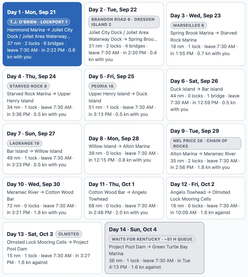
The fourteen day chips of the run from Hammond Marina to Green Turtle Bay Marina, three to a row. Day 1, Mon Sep 21: T.J. O'Brien, Lockport 1; Hammond Marina to Joliet City Dock; 37 nm, 2 locks, 6 bridges, leave 7:30 AM, in 2:22 PM, 0.6 kn with you. Day 2: Brandon Road 6, Dresden Island 2, Joliet to Spring Brook Marina. Day 3: Marseilles 6, to Starved Rock Marina. Days 4 to 13 down the Illinois and the Mississippi to Olmsted, each with its locks, its miles, its leave time and its arrival. Day 14, Sun Oct 4: waits for Kentucky, about 51 h queue; Project Pool Dam to Green Turtle Bay Marina, in Tue 4:13 PM.
One chip per day, Hammond to Green Turtle Bay: the night it ends at, the locks it passes, when it leaves and when it gets in.

Days, not one long night

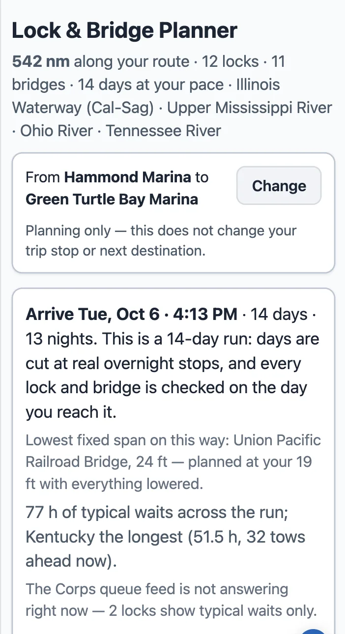
The top of the Lock & Bridge Planner on a phone: 542 nm along your route, 12 locks, 11 bridges, 14 days at your pace, Illinois Waterway (Cal-Sag), Upper Mississippi River, Ohio River, Tennessee River. From Hammond Marina to Green Turtle Bay Marina, with a Change button. Arrive Tue, Oct 6 · 4:13 PM · 14 days · 13 nights. This is a 14-day run: days are cut at real overnight stops, and every lock and bridge is checked on the day you reach it. Lowest fixed span on this way: Union Pacific Railroad Bridge, 24 ft. 77 h of typical waits across the run; Kentucky the longest (51.5 h, 32 tows ahead now).
The run's verdict at the top of the page: when you get in, how many days, and the longest wait on the way.

Tools → Lock & Bridge Planner. When your run does not fit in a day, a row of day chips appears under the controls: "Day 1 · Mon, Sep 21 — Hammond Marina → Joliet City Dock · 37 nm · 2 locks · 6 bridges · leave 7:30 AM · in 2:22 PM". Tap a day and the page below is that day: its map, its staircase, its locks and bridges in order, its cards. On a phone the chips stack and the day you tap opens under its chip.

Every gate on its own day
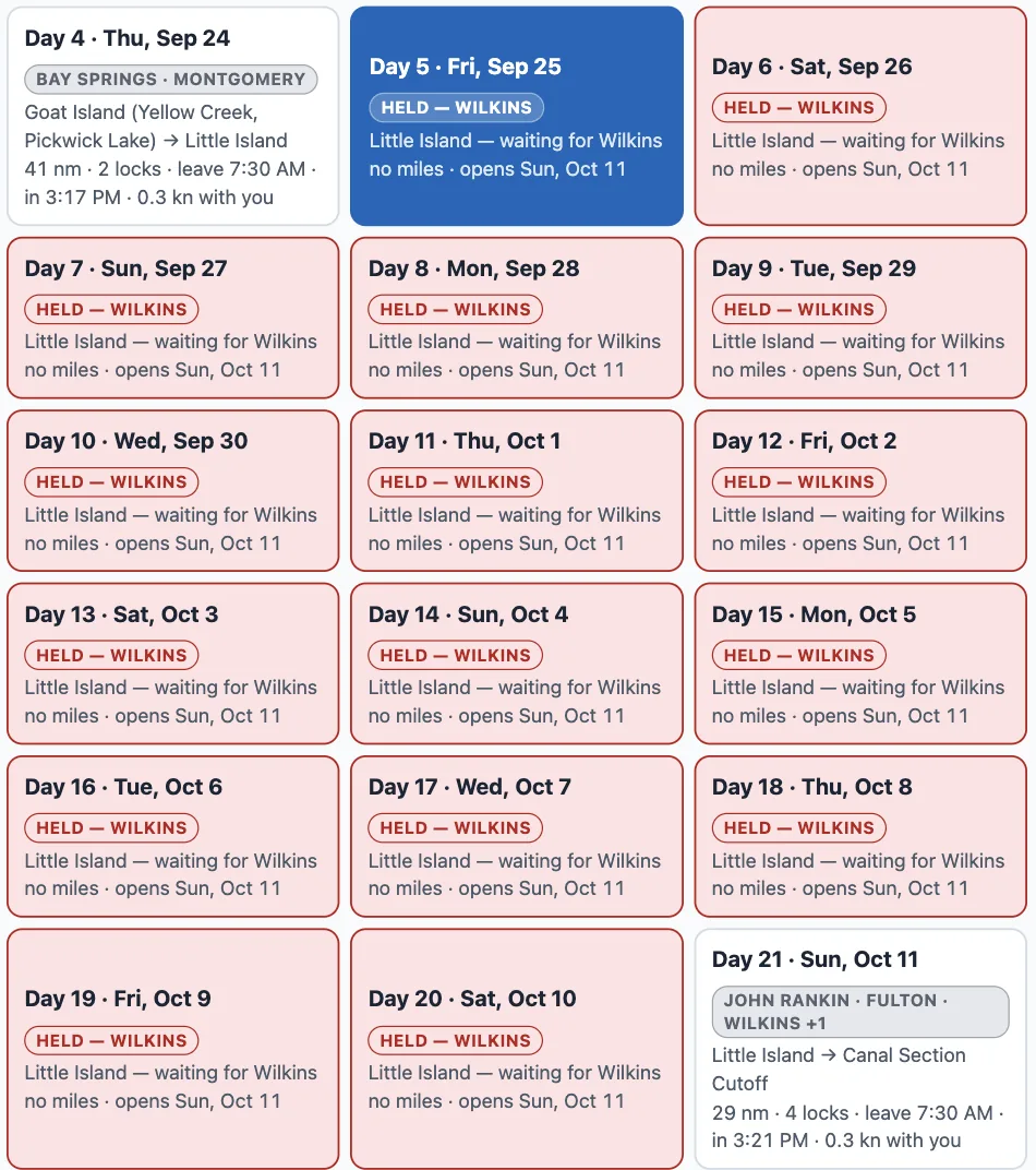
The day chips of a run from Green Turtle Bay to Demopolis down the Tenn-Tom: Day 4, Thu Sep 24, Goat Island to Little Island, 41 nm, 2 locks; then sixteen red chips, Day 5 Fri Sep 25 through Day 20 Sat Oct 10, each reading HELD — WILKINS, Little Island — waiting for Wilkins, no miles, opens Sun Oct 11; then Day 21, Sun Oct 11, Little Island to Canal Section Cutoff, 29 nm, 4 locks.
A different run, Green Turtle Bay to Demopolis: the red chips are the days the boat waits at Little Island for Wilkins Lock to reopen.

Wilkins Lock on the Tenn-Tom is closed through October 10. Leave Green Turtle Bay for Demopolis on September 21 at 8 hours a day and you reach it Friday September 25 — so the plan holds the boat at Little Island, one red chip per day, until the lock opens on October 11, and the days after it carry on from there. No day is planned through a gate that is shut on that day.

Two ways on
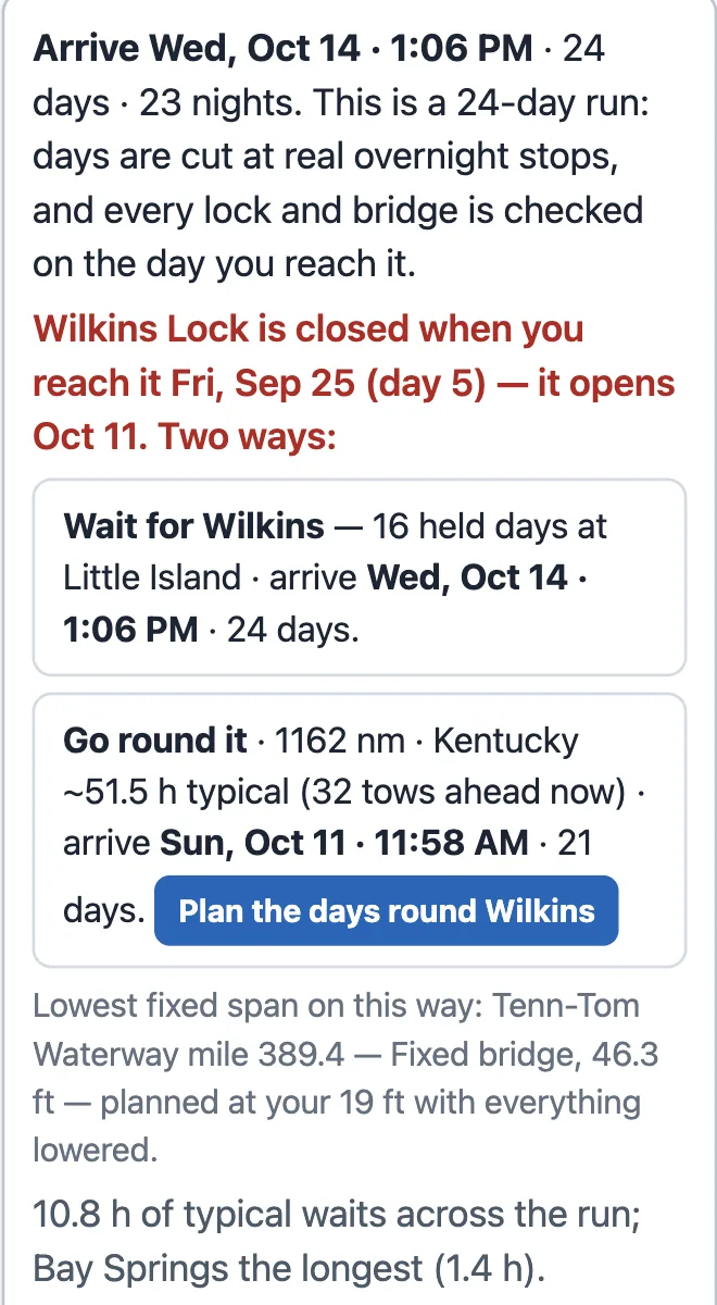
The run's verdict on a phone: Arrive Wed, Oct 14 · 1:06 PM · 24 days · 23 nights. In red: Wilkins Lock is closed when you reach it Fri, Sep 25 (day 5) — it opens Oct 11. Two ways: Wait for Wilkins — 16 held days at Little Island · arrive Wed, Oct 14 · 1:06 PM · 24 days. Go round it · 1162 nm · Kentucky ~51.5 h typical (32 tows ahead now) · arrive Sun, Oct 11 · 11:58 AM · 21 days, with a button Plan the days round Wilkins. Below: lowest fixed span on this way, Tenn-Tom Waterway mile 389.4, 46.3 ft; 10.8 h of typical waits across the run, Bay Springs the longest (1.4 h).
The verdict names the lock that stops you, the day you reach it, and prices both ways on.

The verdict at the top says it plainly: "Wilkins Lock is closed when you reach it Fri, Sep 25 (day 5) — it opens Oct 11. Two ways." Wait for it — sixteen held days, arriving Wednesday October 14 at 1:06 PM — or go round it by the Tennessee, the Ohio and the Mississippi: 1,162 nm, arriving Sunday October 11. One tap plans the days the other way.

You own the mornings and the nights
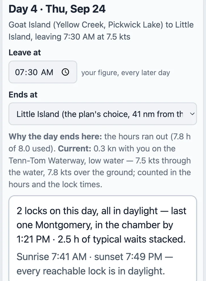
Day 4's card on a phone: Day 4 · Thu, Sep 24, Goat Island (Yellow Creek, Pickwick Lake) to Little Island, leaving 7:30 AM at 7.5 kts. Leave at 07:30 AM — your figure, every later day. Ends at: Little Island (the plan's choice, 41 nm from the day's start), a dropdown. Why the day ends here: the hours ran out (7.8 h of 8.0 used). Current: 0.3 kn with you on the Tenn-Tom Waterway, low water — 7.5 kts through the water, 7.8 kts over the ground; counted in the hours and the lock times. 2 locks on this day, all in daylight — last one Montgomery, in the chamber by 1:21 PM · 2.5 h of typical waits stacked. Sunrise 7:41 AM · sunset 7:49 PM — every reachable lock is in daylight.
A day's card: Leave at, Ends at, why the day ends where it does, and what the day's locks do.

"Hours a day" (your boat profile's figure) decides the cut; a day never plans past sunset unless you leave late on purpose. Each day's card has "Leave at" and "Ends at" — pick a different marina or anchorage from the ones near the cut, and the days after it re-plan; the days before it stand. Nothing is written to your trip: the plan lives in the link.

Where to find it

Tools → Lock & Bridge Planner. Pick any two places with Change, or let it take your trip's next leg. It needs an active trip: the plan runs on your boat's speed, air draft and hours a day.